chapter 2
Oceans and Continents
The ocean is everything. It covers seven-tenths of the
terrestrial globe. Its breath is pure and healthy. It is an
immense desert, where man is never lonely, for he feels life
stirring all around. ... The ocean is the vast reservoir of
Nature. The globe began with the ocean, so to speak, and
who knows if it will not end with it. … — Jules Verne (1870)
The Big
Questions
1. What are oceans
and continents?
What are their
names and their
distribution?
2. In what ways
do oceans and
continents
impact life on
Earth, including
human life?
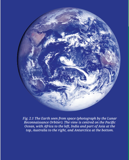
Let us return to our globe and rotate it gently. Or look at
the picture of the Earth seen from the Moon. What is the
most widespread colour you see? Blue, obviously, but what
does it represent? You must have guessed the answer — it
is ‘water’. This means that most of the Earth’s surface is
actually covered with water — almost three-fourths of the
surface, in fact. That is why, when seen from outer space,
the Earth appears mostly blue. Indeed, early astronauts
lovingly called the Earth the ‘blue planet’.
The largest water bodies we see on the globe are called
‘oceans’.
But in the picture of the Earth (Fig. 2.1), you can see at least
one other colour, brown. This colour is that of land, which
covers a little over one-fourth of the globe. A large body of
land is called a ‘landmass’, and a large continuous expanse
of land is called a ‘continent’.
Both oceans and continents play a vital role in shaping the
climate of the Earth. They affect all aspects of life, including
all plants and animals, and therefore, human life too. We
see their impact throughout our history and culture, and in
our daily lives.
DON’T MISS OUT
The emblem of the Indian Navy
contains the motto Sam noh Varunah
(pronounced ‘ŚhamnoVaruṇah’), which
means, “Be auspicious to us, O Varuna.”
This is an invocation to Varuṇa, a Vedic
deity associated with the oceans, the
sky, and water in general.
The Distribution of Water and
Land on the Earth
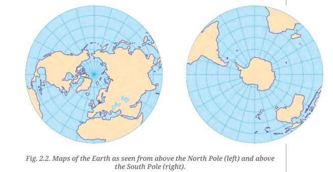
As it happens, oceans and continents are not distributed
equally between the Northern and Southern Hemispheres.
Let us examine the two maps in Fig. 2.2. Here too, the blue
areas consist of oceans, along with their smaller extensions,
which have various names — ‘sea’, ‘bay’, ‘gulf’, etc
Definitions
for these
terms are in
the Glossary
at the end of
this textbook
LET’S EXPLORE
----> What are the circular lines in each map called? And do
you know what the lines radiating out of the two poles are
called? (Hint: you studied them in the previous chapter, but
here they are presented differently.)
---> Which hemisphere holds more water?
----> What do you think could be the approximate proportion
of water to land in the Northern Hemisphere? And in the
Southern Hemisphere? Discuss in groups.
----> Are all the oceans connected with one another, or are there
separations between them ?
The oceans together hold most of the water available on the
planet. But this seawater is salty and unfit for consumption
by most land animals, including humans. On the other
hand, freshwater makes up a very small proportion of the
planet’s water resources; it is found in glaciers, rivers, lakes,
in the atmosphere and also underground (the last is called
‘groundwater’).
THINK ABOUT IT
- If there is such abundance of water on the planet, why is
there so much talk of ‘water scarcity’ or a ‘water crisis’?
- What ways of saving water are you aware of? Which
ones have you seen practised at home, at your school,
and in your village, town or city?
Oceans
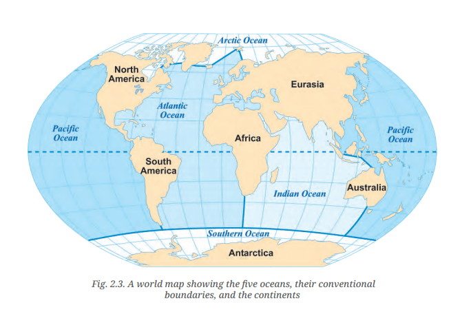
On the world map in Fig. 2.3 on page 32, we can observe
five oceans — the Pacific Ocean, the Atlantic Ocean, the
Indian Ocean, the Arctic Ocean and the Southern (or
Antarctic) Ocean.
Although we have listed five oceans, it is clear from the
map that they are not really separate. The lines that divide
them on the map are no more than conventions — the
natural world does not follow such boundaries. Seawater,
for example, constantly flows across different oceans,
sustaining a rich diversity of marine life. Many plant and
animal species can be found across multiple oceans.
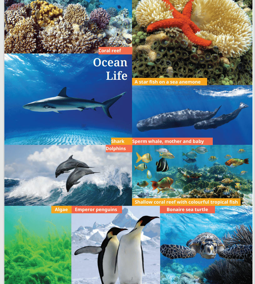
The marine flora includes tiny plants called algae and all
kinds of seaweeds; the marine fauna consists of thousands
of species of colourful fish, dolphins, whales, and countless
mysterious deep-sea creatures. Each part of the ocean, from
the sun-lit surface to the dark depths, has its own diverse
life forms.
Marine:
Related to
or found in
the oceans
and seas.
Flora:
The plant
life of a
particular
region or
period of
time.
Fauna:
The animal
life of a
particular
region or
period of
time.
LET’S EXPLORE
Locate the five oceans and, in the table below, mark the
hemisphere or hemispheres they belong to .
|
Northern
Hemisphere
|
Southern
Hemisphere
|
Pacific Ocean
|
|
|
Atlantic Ocean
|
|
|
Indian Ocean
|
|
|
Southern Ocean
|
|
|
Arctic Ocean
|
|
|
It is visible on the map that the Pacific Ocean is the largest
of all, followed by the Atlantic Ocean. The Indian Ocean is
the third largest, while the Southern Ocean is the fourth.
The smallest one is the Arctic Ocean.
DON’T MISS OUT
- As the map of oceans makes clear, the main limits of the
Indian Ocean are Asia to the north, Africa to the west and
Australia to the east, apart from the Southern Ocean in the
south .
- On either side of India, we find two parts of the Indian
Ocean — the Arabian Sea to the west and the Bay of Bengal
to the east .

Fig. 2.4 (on the right). This map of India is
the same as Fig. 1.6, but with the addition of
the Arabian Sea and the Bay of Bengal. Also
marked are India’s two major groups
of islands (see subsection on ‘Islands’
further below).
Oceans and disasters
Returning to the picture of the
Earth at the start of this chapter,
you may have noticed white
shapes across the globe. Did you
guess what they are? They are
large masses of clouds. Such clouds
bring rain to the continents; for
instance, the monsoon rains we
in India expect every summer
originate in the ocean — without
such rains, our agriculture and all life will suffer. But oceans
often also give rise to storms — violent events with extreme
rainfall or very strong winds, such as cyclones, which can
cause widespread damage to coastal regions of the world.
A tsunami is another natural disaster that originates in the
ocean. It is a huge and powerful wave generally caused by
a strong earthquake or a volcanic eruption at the bottom
of the ocean. Tsunamis can travel thousands of kilometres
and submerge coastal areas, causing widespread damage.
DON’T MISS OUT
On 26 December 2004, India and another 13 countries
around the Indian Ocean were struck by a powerful
tsunami caused by an earthquake in Indonesia. More
than two lakh people lost their lives. In India, the
Andaman and Nicobar Islands (see Fig. 2.4 above, and
also the subsection ‘Islands’ further below) and the
coasts of Tamil Nadu and Kerala were severely affected
and suffered much damage and loss of life.
Such tsunamis are rare but very destructive. Luckily,
they can often be detected before they hit a coast. Many
countries collaborate in such ‘early warning systems’.
There is, in particular, an Indian Ocean Tsunami
Warning System, to which many countries, including
India, contribute. This helps to take measures to protect
lives and property.
Events that lead to loss of life and property are handled
under disaster management. India has its own
‘National Disaster Management Authority’ to deal with
all kinds of disasters (we will see more examples in the
next chapter).
Continents
Continents are visible on the map of oceans (Fig. 2.3). How
many can you count? The answer is not so simple, as they
can be counted in several ways. Depending on our choice,
we may list any number of continents between four and
seven! Here is why :
- North America and South America are generally
considered to be two continents; but if seen as a single
landmass, they can also be considered as one.
- Europe and Asia are generally considered as two
continents, although the map makes it clear that they
form a single landmass. For historical and cultural
reasons, Europe’s evolution has been very different
from Asia’s, which is why they can be seen as two
continents. Geologists, however, often regard them as
a single continent called ‘Eurasia’.
- Africa and Eurasia are generally regarded as two
continents, but sometimes as one.
Let us summarise the different counts in a table:
Count of continents (in alphabetical order)
|
Four continents
|
Africa-Eurasia, America, Antarctica, Australia
|
Five continents
|
Africa, America, Antarctica, Australia, Eurasia
|
Six continents
|
Africa, Antarctica, Australia, Eurasia, North
America, South America (this is reflected in
Fig. 2.3 on page 32 )
|
Seven continents
|
Africa, Antarctica, Asia, Australia, Europe, North
America, South America
|
In practice, the last list of seven continents is the one most
widely adopted and used.
DON’T MISS OUT
You may have seen the five Olympic
rings, one of the symbols of the
Olympic Games. They symbolise
the gathering of sportspeople from
all over the world. The rings were
chosen to represent five inhabited
continents — Africa, America, Asia,
Australia and Europe.
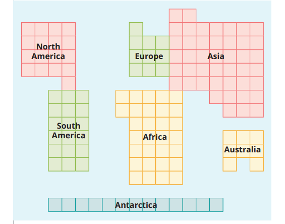
Now let us look at the diagram on page 36, which is based
on the list of seven continents. It does not show their actual
shapes, but their relative sizes .
LET’S EXPLORE
- Counting the numbers of squares, name the largest
continent and the smallest .
- Which one is larger — North America or South America?
Africa or North America? Antarctica or Australia?
- Re-colour the diagram by having a single colour for
Europe and Asia and rename the result as ‘Eurasia’.
Compare its size with South America’s.
- Write down the list of continents from the smallest to the
largest .
Islands
If you have carefully observed the two maps earlier in
this chapter (Fig. 2.2 and 2.3), you may have noticed that the continents do not include all landmass. Some smaller
pieces of land are left out; surrounded by water on all sides,
they are called islands. (Continents are also surrounded
by water, but because they are so large, they are not
considered islands.)
There are lakhs of islands on the planet, of very different
sizes.
DON’T MISS OUT
- Greenland is the largest island in the world (locate it on a
globe or a map). You would have to add the areas of the 10
largest states of India to reach its size .
- India has more than 1,300 small islands! Those include
two major groups — Andaman and Nicobar Islands in the
Bay of Bengal and Lakshadweep Islands in the Arabian Sea
(see Fig. 2.4) .
- Since 1981, the Indian Antarctica Programme has been
exploring Antarctica, a continent with a very cold climate
and harsh environment (see the white expanse at the
bottom of Fig. 2.1, which is mostly ice). In 1983, India
established its first scientific base station there, called
‘Dakshin Gangotri’ (two more bases were established
later). About 40 teams of Indian scientists have conducted
research in this faraway region, especially on the evolution
of climate and environment. The settlement where the
scientists live has a library and even a post office!
Oceans and Life
Oceans and continents are vital parts of the environment
and affect most aspects of our lives, even if we do not
notice it. We have mentioned that oceans send rain to the
continents; this is part of the Earth’s water cycle, which
you will further study in Science. Without oceans, for instance, there would be no rainfall! The Earth would be a
desert. Moreover, more than half of the world’s oxygen is
produced by the oceans’ flora, which is why they are called
‘the planet’s lungs’. The oceans, therefore, play a crucial
role in regulating the climate and sustaining life on Earth.
Oceans have deeply impacted humanity in many other
ways. From early times, people have used oceans and seas
to migrate to other regions, to trade in all kinds of goods,
to conduct military campaigns, and as a source of food
through fishing. Oceans have also nourished the cultures
of coastal people all over the world. Almost all of them have
tales and legends about the sea, sea gods and goddesses, sea
monsters and treasures from the sea — the oceans’ dangers
but also their blessings.
DON’T MISS OUT
The United Nations has designated June 8 as World Oceans Day
to “remind us all of the major role the ocean plays in everyday
life. It serves as the lungs of our planet, a major source of
food and medicine and a critical part of the biosphere.”
Scientific studies have shown how the oceans are polluted
by human activity — we throw several million tonnes of
plastic waste into the oceans every year, choking marine life.
There are several other forms of pollution. As a result, the
marine environment is under threat. Overfishing (excessive
fishing) is another cause for the decline of marine life.
It is our collective responsibility to protect oceans for the future
of the planet and of humanity
Before we move on
------>The Earth’s surface has vast water bodies called ‘oceans’
and large landmasses called ‘continents’. Oceans are
interconnected. Continents may be counted in various
ways; the most common count is seven.
-------->The Northern Hemisphere has more land than the
Southern Hemisphere.
-------->Oceans support all kinds of marine life and play a critical
role in the world climate. They are now seriously affected
by human activity and need our collective protection.
Questions, activities and projects
1. Explain the following terms
(a) Continent
(b) Ocean
(c) Island
2. Let us draw – Without looking at the maps in this chapter,
draw the continents free hand on a sheet of paper and
colour them. Then compare your drawing with the map of
oceans and continents in the chapter .
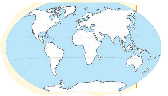
3. Let us do – On the outline map of the world given below,
label all the continents and oceans.
4. Solve this crossword
Across
1. Abundantly produced by the oceans
3. A large expanse of landmass
6. A large continent of which India is a part
8. A major source of pollution of the oceans
10. The coldest continent
Down
2. The largest island on Earth
4. A huge destructive wave from the ocean
5. The smallest continent
7. The largest body of water on the Earth
9. A landmass (but not a continent) surrounded by the sea or ocean