
3 Climates of India
"kāle varṣhatu parjanyaha pṛiṭhivī sasyaśhālinī
deśhoyam kṣhobharahitah brāhmaṇāsantu nirbhayāh
May the rains be timely, may the Earth be lush with vegetation
May this country be free from turmoil, may good people be fearless!"
— Subhāśhita
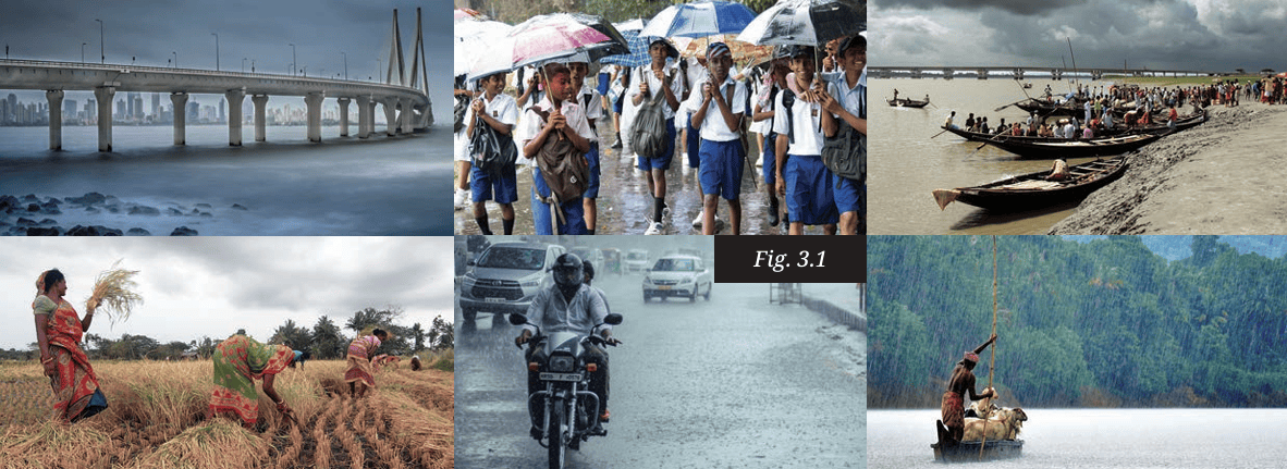
The Big Questions?
1. What makes India’s climate so
diverse?
2. What are the monsoons?
How are they formed?
3. What is the effect of climate on
economy, culture and society?
4. How can understanding the
climate help us to prepare
for natural disasters?
5. What is climate change? What are
its consequences?
Weather, Seasons and the Climate
‘Climate’ is a word people use in everyday conversations. But, quite often, what they really mean is ‘weather’, and not ‘climate’. What’s the difference? ‘Weather’ is what we experience every hour or day: it might be raining, or there could be bright sunshine, a lot of wind, etc. The weather keeps changing. Climate, on the other hand, is the pattern of weather an area or a region experiences over a long period of time — several decades at least. This pattern varies from region to region.
Before we come to the various types of climates, let us briefly stop
to introduce seasons. Seasons occur as the Earth revolves around
the Sun. Each season lasts for a few months and recurs every
year. As we know, there are several seasons in the year — spring,
summer, monsoon, autumn and winter — that occur in a cycle.
Are seasons related to the weather or to the climate? The answer
is: to both.
The weather changes with the season, that is, it can be dry and
hot in the summer months, or humid and rainy during the
monsoon. Further, the pattern of seasons in a region is closely
connected with the climate. There are four main seasons across
most regions of the world — spring, summer, autumn and winter.
However, India receives rainfall during a specific period of the
year — the ‘rainy season’ or monsoon — along with the other four.

If we observe the world around us, we will notice that human,
plant and animal life are in rhythm with the ṛitus or seasons.
The crops we grow, the food we eat, the clothes we wear, and so
on, change with the season. Depending on the region, some trees
and shrubs bloom with the onset of vasanta or spring, in some
places they shed their leaves or change their colour as śharad or
autumn approaches and some animals develop thick fur in the
cold winter months.
- Which are your favourite seasons? Write a short essay explaining your reasons.
- Discuss in groups of three or four and find out whether there are specific events connected to the seasons in your region. Collect information about them — songs, feasts with specific types of food, practices in different seasons, etc. Document these and share your discoveries with your class.
- Do you know which trees in your area change colours
before the onset of winter? Are there trees that shed their
leaves around this time? Why do you think this happens?
Find out and document the local names of these trees.
Usually, the climate remains stable over long periods of time.
However, scientists have been recording changes in the climates
of the world in the recent decades. Studies show that many of
these changes have been caused by human actions.
Let us recapitulate:
- Weather is what we experience from day to day — windy,
rainy, hot, dry, etc.
- Seasons recur every year and the weather of a place is
different in every season.
- Climate is the long-term pattern in a particular region. There
are many types of climates in the world. We will now survey
the main types found in India.
Types of Climates in India
We have often seen how India is a land of diversity. This is
equally true of its climate:
- In the north, the Himalayan mountains have an alpine
climate with cold, snowy winters and cool summers (the
word ‘alpine’ comes from the Alps, a mountain range of
Europe). That’s probably where you will see the thickest
clothing in India!
- Lower in the Himalayas, and in many hilly areas of India, the climate is often said to be temperate, as the winters are moderately cold and the summers not too hot. That is where we find many ‘hill stations’, much frequented by people seeking relief from the heat in the plains below.
- In the northern plains, the climate is subtropical, with very hot summers and cold winters. This is where most of India’s wheat is grown.
- In the west, the Thar Desert has an arid climate featuring extremely hot days, cool nights, and very little rainfall. People there have had to develop unique ways to collect and save water.
- The western coastal strip receives heavy rainfall during
monsoon months, creating a tropical wet climate, which is
favourable to the growing of rice and spices.
- The central Deccan Plateau has a semi-arid climate with hot
summers, mild winters and moderate rainfall during the
rainy season.
- Eastern India and the southern peninsula experience a
tropical climate with a mild winter and distinct wet and dry
periods controlled by monsoon winds (more on them soon).
Note: You will understand later the meaning of the terms
‘tropical’ and ‘subtropical’, which are related to two special
parallels of latitude called the ‘tropics’.
Factors Determining the Climate
What creates those different climates? There are many factors at work. Some are general ones — on the scale of the planet — while others are regional or even local. Let’s examine a few.a) Latitude
LET’S REMEMBER
We studied about latitudes in Grade 6. Do you remember that
latitudes measure the distance from the Equator, increasing
as we move away from it (either northward or southward)?
While the climate around the Equator is extremely hot, as
the latitude increases it becomes temperate and then cold or
frigid. Why is this so?
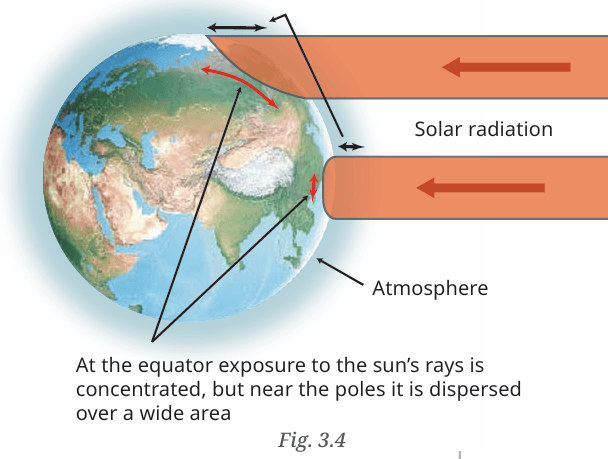
Places near the Equator,
that is, at low latitudes,
are warmer, while those
near the poles (high
latitudes) are colder.
This happens due to the
angle at which the sun’s
rays hit a particular
area. At the Equator,
the rays are nearly
perpendicular, and so all
their energy is focused
on a smaller area of the
Earth’s surface. In the
polar regions, the rays are inclined or oblique, and the energy
is distributed over a larger surface. Moreover, they have to pass
through more of the Earth’s atmosphere, as the diagram shows,
which further dissipates their energy. As a result, the polar
regions receive less heat than the equatorial zone. We can see
this in India too: Kanniyakumari and the Nicobar Islands being
close to the Equator are warm or hot almost throughout the year,
whereas places in the north, such as Srinagar, are much cooler.
b) Altitude
We mentioned hill stations above, which are popular tourist
centres because of their cooler climate. India has many
including Munnar, Theni, Udhagamandalam (Ooty), Madikeri,
Mahabaleshwar, Mount Abu, Shimla, Nainital, Darjeeling,
Tawang, Shillong, etc. We know they are located at a higher
altitude than the plains below, but how does that explain their
cooler temperature? You will later learn the full answer in your
Science classes.
To keep things simple for now, the temperature decreases as the
altitude increases because:
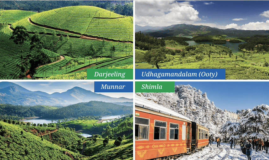 Fig. 3.5
1. The atmospheric pressure, and therefore the air density, decreases as the altitude increases (as we saw in the chapter ‘Understanding the Weather’), and as the air gets less dense, it gets cooler.
2. The sun heats the surface of the Earth, and so the farther away from the surface, the less hot the air will be. The Himalayas are so high that many peaks maintain a temperature below water’s freezing point, keeping them covered in snow.
LET’S EXPLORE
Udhagamandalam (Ooty) and Coimbatore are almost at the
same latitude. The range of summer temperatures in Ooty is
10–25° while that in Coimbatore is 25 –38°. Why do you think
there is such a difference in temperature between these two
places?
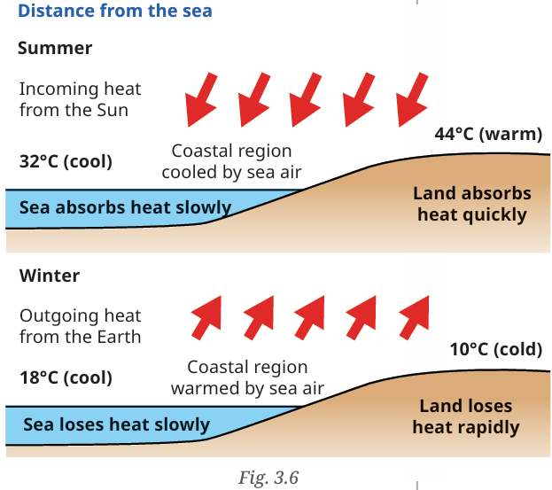
c) Proximity to the sea
Temperatures in coastal
areas do not vary much;
the summers are not
too hot and the winters
are not too cold. That
is
because the sea
acts as a moderator
for the temperature.
This diagram sums up
the phenomenon, and your Science textbook
explains this further while discussing the
heating and cooling
of land and water in
coastal regions. The
result is that those
regions tend to be more temperate. As you move inland from the coast, the temperatures get more extreme — summer
temperatures will be higher and winter temperatures lower. For
instance, Mumbai and Nagpur are located at a similar latitude,
but Mumbai, being near the sea, has cooler summers (around
32°C) and milder winters (around 18°C), while Nagpur, away
from the coast, experiences up to 44°C in summer and about
10°C in winter. As you can see, Mumbai’s range of temperature
(i.e. the difference between the maximum and the minimum) is
about 14°C while the range at Nagpur reaches 34°C.
d) Winds
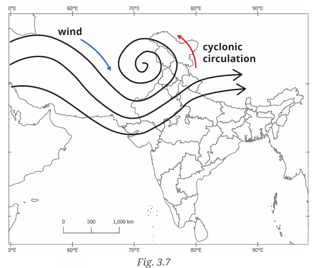
Wind can move masses of warmer or cooler air. States like
Punjab, Haryana, Rajasthan and Madhya Pradesh often receive
winds blowing from the west. Having travelled over the deserts
of Arabia to Afghanistan, they bring dry and hot air that causes
severe heat waves in summer. In winter cold winds from across
the Himalayas creep into the Himalayan foothills, resulting in
cold waves.
Winds affect not only temperature, but also humidity, and in turn, precipitation. We saw dry winds coming from distant deserts; in contrast, winds coming from the sea bring moisture over the land, which may result in rainfall. We will soon see the case of the monsoon winds.
LET’S REMEMBER
In your Grade 6 Science textbook ‘Curiosity’ you studied
the water cycle! “The water from the ocean and the Earth’s
surface evaporates into the atmosphere as vapour and
returns as rain, hail or snow….”
e) Topography
Finally, the topography of a region also plays an important
role in determining its climate. For instance, the Himalayas
and the Karakoram ranges protect, to some extent, the Indian
52
subcontinent from the winds of the cold deserts of Central Asia.
The nearly flat topography of the Thar desert, on the other
hand, has nothing to protect it from hot and dry winds. In the
next section, we will see the role of the Western Ghats in India’s
southwest monsoon.
Topography: The totality of the physical surface features of an area. This may include mountains, hills, valleys, slopes, coasts, etc.
Putting it all together...
The climate of any region is determined collectively by all the
above factors. Describing the climate involves a description of
the patterns of temperature, precipitation (rain or snowfall,
occurrence of fog or mist) and wind conditions in a region over
three decades or more.
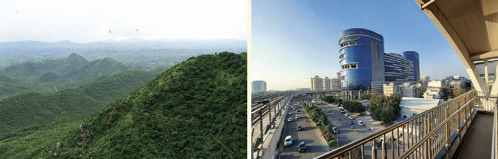
Microclimates can influence the local flora and fauna, the crops grown, and impact human health and well-being.
The Monsoons
The monsoon season is central to life in India. During the
monsoon months, the rivers fill up, the soil is soaked with
water, crops grow and life thrives. Strictly speaking, the word
‘monsoon’, which comes from the Arabic word mausim, meaning
‘season’, refers to seasonal winds over a large area of the Indian
Ocean and surrounding regions, including Australia, Africa and
South Asia.
There is a yearly pattern to the monsoons. Their mechanism
is complex, but based on the simple fact that land heats up
or cools down faster than the ocean. Monsoons bring out the
fundamental relationship between temperature, pressure and
wind movement.
To put it simply, as summer begins, the Asian landmass heats
up, creating a powerful low-pressure system over it. Since air
always flows from high pressure to low pressure, winds are
drawn from the cooler, high-pressure ocean towards the hot
land. These ocean winds carry moisture that condenses over
the warmer land and falls in the form of heavy monsoon rains.
(That is why ‘monsoon’ commonly refers to the seasonal rains
rather than the winds.)
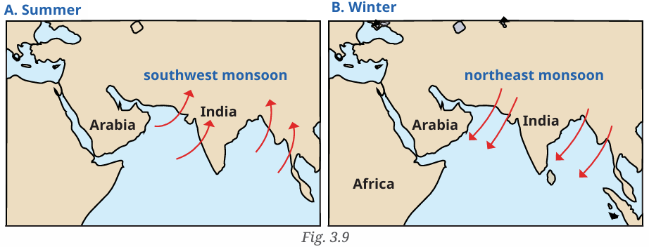
The pattern reverses in winter, when the landmass cools down
more rapidly than the ocean. Now the land has a high-pressure
system while the ocean remains warmer with relatively
lower pressure. This causes the winds to blow in the opposite
54
direction — from the land towards the ocean — bringing dry
conditions to much of Asia.
Coming to India, the monsoon rains typically advance from
the southern tip of India in early June, moving northward over
several weeks until they cover the entire subcontinent by mid
July. It is not a smooth progression, though the Western Ghats
(remember our brief survey of topography) act as a natural
barrier; their western slopes receive much rainfall, while
the Deccan plateau to the east receive less, and often with
interruptions. This is commonly called the summer or southwest
monsoon (‘southwest’ reflecting the direction the winds come
from).
As winter approaches, the winds reverse and blow from the
land to the ocean, as we just saw. These are dry winds that bring
cold weather to south India, but a part of them, passing over the
Bay of Bengal, collect some moisture and bring rainfall to parts
of east and south India. This is called the winter or northeast
monsoon.
- Mawsynram, located in Meghalaya, receives the highest average annual rainfall in the world, about 11,000 mm (which is the same as 11 metres!).
- The monsoons have inspired many ragās in both Carnatic and Hindustani classical music. Meghamalhār and amruthavarshini are names of a couple of them.
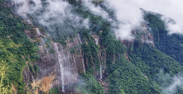
Fig. 3.10
LET’S EXPLORE
Since the ability to predict the monsoon rainfall has been
an important aspect of life in India, our ancestors observed
Nature around them carefully. They developed local
traditional knowledge through their experience. This
traditional knowledge is an important heritage we must
preserve. For example, fishermen on the Konkan coast
predict the onset of the monsoon when fishes that normally
stay under water are seen at the surface; in parts of southern
India monsoon is said to arrive within 50 days after the Golden
Shower tree (Cassia fistula) blossoms. Some communities also
believe that when crows build their nests high on tree-tops, it
indicates less rainfall, whereas if the nests are lower, rainfall
is likely to be heavy. Make a list of such local knowledge about
rain, fog, snow or hail in your area.
Climate and our Lives
Our lives are deeply connected with the climate and dependent on it. The impact of climate is visible in local cultures for instance, and India has many festivals associated with seasons and agricultural activities.LET’S EXPLORE
Reach out to your grandparents or elders in your
neighbourhood. Ask them about the traditional festivals
and dances they remember from their childhood and youth,
especially those related to agriculture and rain. What rituals
did they participate in? Then organise a cultural fest with
your friends. You can showcase some of the dances, songs
and activities your elders shared with you. Whether it is a
dance, harvest ritual, or a simple story about a prayer to rain
gods, try to bring these traditions to life for your classmates.

The climate also has a direct impact on the economy. For instance, you may have heard the phrase ‘monsoon failure’, which refers to poor rainfall during the monsoon season; in such a case, the agriculture suffers, people (women, generally) have to walk long distances in search of water, and agricultural labourers are likely to migrate to the cities; food (grains, vegetables and fruits, to begin with) becomes costlier, fuelling inflation. Industrial activity also often depends on a predictable weather and the availability of water. The world over, we can easily detect such connections between the climate and socioeconomic conditions. Those conditions get especially strained when climate disasters strike.
Climates and Disasters
India’s diverse weather patterns can bring about extreme conditions such as cyclones, floods, landslides and other such climate-related disasters. These events affect people’s lives, disrupt agriculture, damage infrastructure and disturb local economies.a) Cyclones
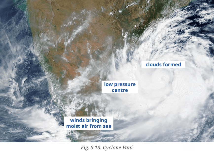
Every year, the Indian coastline, especially the eastern coast, witness several cyclones. In past years, some of them have been highly destructive, resulting in the loss of human and animal life, damaging property and infrastructure, uprooting trees and causing soil erosion. The India Meteorological Department (IMD) keeps track of coming cyclones and provides information on their formation, evolution, place of landing, etc.
DON’T MISS OUT
 The National Disaster Response Force
(NDRF) is specially trained to respond
to natural as well as human-made
disasters. NDRF battalions are located
at 12 different locations in India. The
NDRF has played a key role in rescue
and evacuation during disasters like
cyclones, landslides and floods.
The National Disaster Response Force
(NDRF) is specially trained to respond
to natural as well as human-made
disasters. NDRF battalions are located
at 12 different locations in India. The
NDRF has played a key role in rescue
and evacuation during disasters like
cyclones, landslides and floods.
How are cyclones formed? We saw that in some special situations, the atmospheric pressure near the sea becomes lower than the surrounding areas, creating a low-pressure system. This is an invitation to the air from surrounding areas to come into the low-pressure area, and the air from the sea moves in, bringing with it moisture and rain. When the low pressure system is intense and the wind speeds are high, this may result in a cyclone.
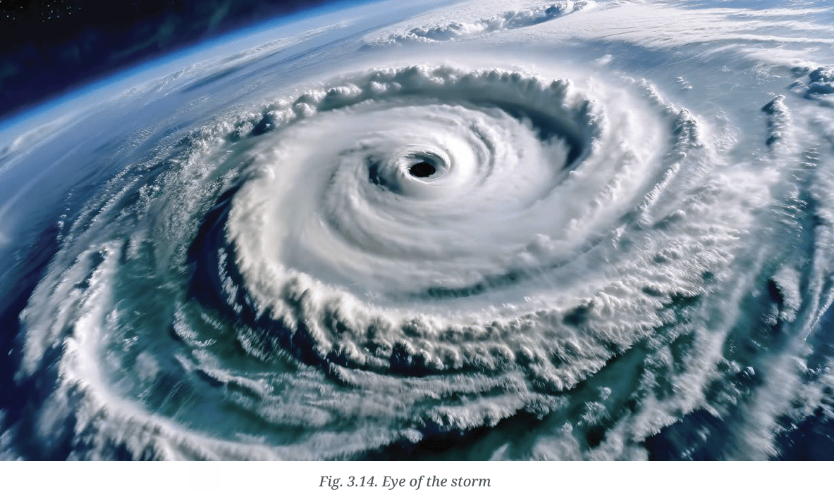
As winds collect moisture, they form clouds and rotate inwards towards the centre of the depression. This centre, which is cloudless, is called ‘the eye of the cyclone’.
THINK ABOUT IT
What are clouds? White lumps in the sky, you might say.
But what are they made of? The answer is simple — water.
But not just any water; clouds are masses of water droplets,
ice crystals, or a mixture of both, that are suspended in the
atmosphere.
b) Floods
A flood occurs when water overflows into normally dry land. This could be due to heavy rainfall generating huge run-off water that the land cannot absorb, or due to excessive accumulation of water in bodies like rivers and lakes, until the water overflows Exploring Society: India and Beyond | Grade 7 Part 1 60 or their banks are breached. Floods occur frequently during the monsoons. States such as Uttar Pradesh, Bihar, Kerala, Andhra Pradesh and Assam are particularly vulnerable to floods.LET’S EXPLORE
Have you seen or read about floods? Look at the physical
map of India. Discuss in pairs why you think floods occur in
the areas mentioned above.
DON’T MISS OUT
In 2013, Uttarakhand experienced a sudden glacial burst
caused by continuous heavy rain over several days. Many
landslides followed. Areas around one of India’s important
sacred sites, the Kedarnath temple, were completely
destroyed. Several villages were washed away in the floods,
along with many roads and bridges. Altogether about 6,000
people, many of them pilgrims, lost their lives.
c) Landslides
A landslide is the sudden collapse of rock, soil, or debris, often triggered by heavy rain, earthquakes or volcanic activity. Landslides are common in hilly and mountainous regions such as Himachal Pradesh, Uttarakhand, Sikkim and Arunachal Pradesh, as well as the Western Ghats and hilly regions. These events often occur during the monsoon.In those regions, the chances of landslides have increased due to human activities such as the cutting down of forests, building infrastructure without following approved methods and the construction of too many buildings that block the natural flow of water.
d) Forest fires
Forest fires are uncontrolled fires that spread rapidly across vegetation, often fuelled by dry climatic conditions, droughts or high winds. Human carelessness is another frequent cause. Forest fires are common in states with large forested or grassland areas such as Uttarakhand, Himachal Pradesh, Madhya Pradesh and Chhattisgarh, as well as mountain ranges such as the Western Ghats. Apart from destroying large areas of forest, fires harm wildlife, degrade the ecosystem, spoil the air quality and displace local communities. The consequences are therefore both environmental and economic.- Observe Fig. 3.15. Describe the effects they may have on people, plants, animals and economic life.
- In groups of four or five, identify in each of the above disasters the part of natural causes and the part of human causes. Compare your conclusions.
- Discuss in the same groups series of preventive measures that could help avoid the above disasters.
Climate Change
Climate change refers to significant, long-term changes in the climate. This may be on the scale of the planet or on a regional scale, and it involves shifts in temperature, precipitation and weather events. In past millennia (we can go back millions of years, in fact), natural processes drove climate change. Since the 19th century, however, climate change has been largely driven by human activities, particularly the burning of fossil fuels, deforestation, environmentally harmful industrial practices, and production and patterns of excessive or wasteful consumption.Fossil fuels: Sources of energy that were formed from the remains of plants and animals that died millions of years ago and were buried deep under layers of soil and rock or under the sea, where heat and pressure slowly turned them into coal, petroleum oil and natural gas.
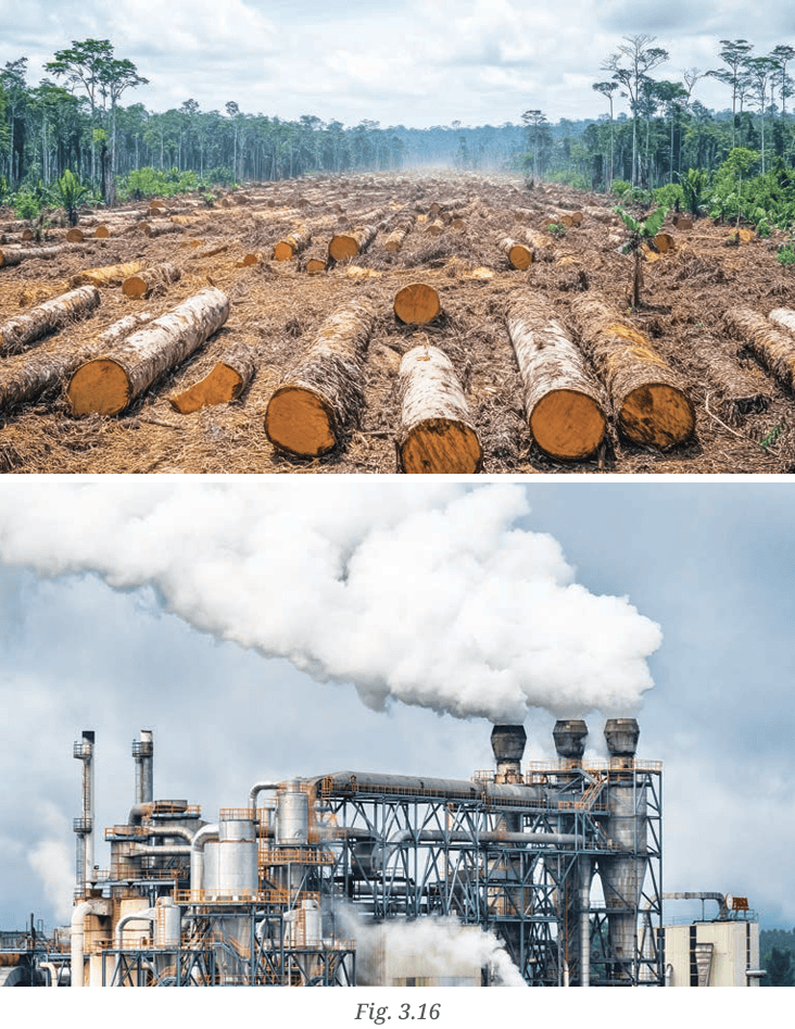 Why does the burning of fossil fuels affect the climate? In the
Earth’s natural carbon cycle, carbon dioxide (CO2
) and other
gases are released gradually into the atmosphere and trap heat
from the Sun. This natural ‘greenhouse effect’ warms Earth
enough to support life. However, human activities like industry,
transportation, and agriculture have released enormous
amounts of these ‘greenhouse gases’ in just a few centuries. This
sudden increase traps extra heat, causing rapid global warming
and disrupting the climate patterns that plants, animals, and
human societies have adapted to over thousands of years.
Why does the burning of fossil fuels affect the climate? In the
Earth’s natural carbon cycle, carbon dioxide (CO2
) and other
gases are released gradually into the atmosphere and trap heat
from the Sun. This natural ‘greenhouse effect’ warms Earth
enough to support life. However, human activities like industry,
transportation, and agriculture have released enormous
amounts of these ‘greenhouse gases’ in just a few centuries. This
sudden increase traps extra heat, causing rapid global warming
and disrupting the climate patterns that plants, animals, and
human societies have adapted to over thousands of years.
In India, rising temperatures are perceptible in many regions. Early in 2025, for instance, the country’s average temperature was 1 to 3°C above normal, as a result of which the winter was much shorter and milder than usual. This affects not only agricultural production but also many small-scale industries. This is only one example showing how a warmer planet will present us with increasing challenges.
Understanding the relationship between the causes of climate change and disasters can help us to prepare better for these challenges. It also supports the need for more environment friendly practices and building resilience and adaptation in communities. Governments worldwide, including India’s, attempt to promote measures of climate mitigation, such as cutting down on greenhouse gas emissions, planting trees, boosting renewable energy and improving energy efficiency, promoting sustainable lifestyles, etc. But these often clash with a desire for economic growth and increased consumption.
Resilience:
The capacity
to withstand
or recover
quickly from
difficulties.
Mitigation:
The adoption
of steps to
help slow
down global
warming
and reduce
the causes
of climate
change.
Sustainable:
Something
which can be
maintained over a
long period
of time.
- India’s diverse climate is shaped by its geography, including mountains, deserts, and plateaus.
- Weather is short-term, seasons recur on a yearly basis, and climate reflects long-term patterns over decades.
- Factors such as latitude, altitude, proximity to the sea, wind and topography determine the climate.
- Monsoons are vital for agriculture, influencing crop cycles and livelihoods.
- Climate is connected with cultural traditions, festivals, agriculture and economic activity.
- Understanding the climate helps prepare for natural disasters like floods and cyclones.
- Climate change leads to extremes of weather or temperature and can have severe consequences on the natural and human worlds.
Questions and Activities
1. Match the climatic factors with their effects:| Column A | Column B |
|---|---|
| (1) Latitude | (b) Creates different climates in the north and south |
| (2) Altitude | (c) Keeps higher places cooler |
| (3) Proximity to the ocean | (d) Moderates the temperature |
| (4) Monsoon winds | (a) Brings wet air to India during summer |
2. Answer the following questions:
- a) What is the difference between weather and climate?
- b) Why do places near the ocean have milder temperatures than places far away from it?
- c) What role do monsoon winds play in affecting India’s climate?
- d) Why is Chennai warm or hot throughout the year, while Leh is cold?
- Is the place near the sea, in the mountains, or in the desert?
- How do these factors affect the climate there?
4. Draw the monsoon cycle in summers and winters on a map of India.
- Label where the winds blow in summer and winter
- Show the direction of winds during the monsoon
5. Make a colourful poster showing festivals in India linked to
farming and weather (e.g., Baisakhi, Onam). Add pictures or
drawings of these festivals.
6. Imagine you are a farmer in India. Write a short diary entry
about how you would prepare for the rainy season.
7. Identify a natural disaster (e.g., cyclone, flood, landslide, or
forest fire) and write a short essay that includes the causes
and impacts. Suggest actions that individuals, communities
and the government can take to reduce the impact.