Table of Contents

8. Winds, Storms and Cyclones

Fig. 8.1 Image taken by a satellite of a cyclone approaching the coast of Orissa
Courtesy: India Meteorological Department, New Delhi
But, what are cyclones? How are they formed? Why are they so destructive? In this chapter we shall seek answers to some of these questions.
We begin with some activities involving air. These activities will clarify some basic features concerning a cyclone. Before we begin, remember that the moving air is called the wind.
8.1 Air Exerts Pressure
Activity 8.1
| Whenever an activity involves heating, be very careful. It is advised that such activities are performed in the presence of an elderly person from your family. Or, carry out these activities in the presence of your teacher. |
You need to boil water in the following activity.
Take a tin can with a lid. Fill it approximately half with water. Heat the can on a candle flame till the water boils. Let the water boil for a few minutes. Blow out the candle. Immediately put the lid tightly on the can. Be careful in handling the hot can. Put the can carefully in a shallow metallic vessel or a washbasin. Pour fresh water over the can.
What happens to the shape of the can?
Can you guess why the shape of the can gets distorted?
If you cannot get a tin can, take a soft plastic bottle. Fill it with hot water. Empty the bottle and immediately cap it tightly. Place the bottle under running water.

Fig. 8.2 Can with hot water being cooled
Recall now some of your experiences.
When you fly a kite, does the wind coming from your back help?
If you are in a boat, is it easier to row it if there is wind coming from behind you?
Do you find it difficult to ride a bicycle against the direction of the wind.
You know that we have to fill air into the bicycle tube to keep it tight. Also, you know that a bicycle tube overfilled with air may burst. What is the air doing inside the tube?
Discuss with your friends how the air in the bicycle tube keeps it in shape.
All these experiences show that the air exerts pressure. It is due to this pressure that the leaves of trees, banners, or flags flutter when the wind is blowing. You can list some more experiences which show that the air has pressure.
Let us now try to explain why the can (or the bottle) gets distorted. As water is poured over the can, some steam in the can condenses into water, reducing the amount of air inside. The pressure of air inside the can decreases than the pressure exerted by the air from outside the can. As a result the can gets compressed.
This activity again confirms that air exerts pressure.
8.2 High Speed Winds are Accompanied by Reduced Air Pressure
Activity 8.2

Fig. 8.3 Blowing into the bottle
Crumple a small piece of paper into a ball of size smaller than the mouth of an empty bottle. Hold the empty bottle on its side and place the paper ball just inside its mouth. Now try to blow on the ball to force it into the bottle. Try the activity with bottles of different sizes. Challenge your friends if they can force the paper ball in by blowing into the bottle.
Paheli and Boojho are thinking about the following question:
Why is it difficult to force the paper ball into the bottle?
Activity 8.3
Blow the balloons
Take two balloons of approximately equal size. Put a little water into the balloons. Blow up both the balloons and tie each one to a string. Hang the balloons 8–10 cm apart on a cycle spoke or a stick. Blow in the space between the balloons.

Fig. 8.4 Blowing between the balloons
What did you expect? What happens?
Try different ways of blowing on the balloons to see what happens.
Activity 8.4
Can you blow and lift?
Hold a strip of paper, 20 cm long and 3 cm wide, between your thumb and forefinger as shown in the Fig. 8.5. Now blow over the paper.
Paheli thinks that the strip will be lifted up. Boojho thinks that the strip will bend down.


Fig. 8.5 Blowing over a strip of paper
Let us try to understand the observations in Activities 8.2, 8.3 and 8.4.
Were the observations along the lines you thought? Do you get the feeling
that the increased wind speed is accompanied by a reduced air pressure?
When we blow into the mouth of the bottle, the air near the mouth has higher speed. This decreases the pressure there. The air pressure inside the bottle is higher than near the mouth. The air inside the bottle pushes the ball out.
In Activity 8.3 you saw that when you blew between the balloons, they moved towards each other. How could this happen? This could happen if the pressure of air between the balloons were somehow reduced. The pressure outside the balloons would then push them towards each other.
We see that the increased wind speed is, indeed, accompanied by a reduced air pressure.
Can you imagine what would happen if high-speed winds blew over the roofs of buildings? If the roofs were weak, they could be lifted and blown away. If you have any such experience, share it with your friends.
Let us try to understand how winds are produced, how they bring rain and how they can be destructive sometimes.
You already know that when air moves, it is called wind. Air moves from the region where the air pressure is high to the region where the pressure is low. The greater the difference in pressure, the faster the air moves. But how are the pressure differences created in nature? Is the difference in temperature involved? The following activities will help you to understand this.

Fig. 8.6 The shape of the balloon in hot and cold water
8.3 Air expands on heating
Activity 8.5
Take a boiling tube. Stretch a balloon tightly over the neck of the tube. You can use a tape to make it tight. Pour some hot water in a beaker. Insert the boiling tube with the balloon in the hot water. Observe for 2–3 minutes for any change in shape of the balloon. Take the tube out, let it cool down to the room temperature. Take some ice-cold water in another beaker and place the tube with the balloon in cold water for 2–3 minutes. Observe the change in the shape of the balloon.
Think and try to answer:
Why is the same balloon deflated when the tube is kept in cold water?
Can we infer from the first observation that air expands on heating? Can you now state what happens to the air in the boiling tube when it cools down?
The next activity is very interesting. This will make you understand more about hot air.
Activity 8.6
Take two paper bags or empty paper cups of the same size. Hang the two bags in the inverted position on the two ends of a metal or wooden stick.
| CAUTION |
| Handle the burning candle carefully. |

Fig. 8.7 Hot air rising up
Tie a piece of thread in the middle of the stick. Hold the stick by the thread (Fig. 8.7) as in a balance. Put a burning candle below one of the bags as shown in the figure. Observe what happens.
Why is the balance of the bags disturbed?
Does this activity indicate that warm air rises up? As the warm air rises up, it pushes the bag above the candle. Does the disturbance of the balance suggest that the warm air is lighter than the cold air?
Can you now explain why smoke always rises up?
Also, it is important to remember that on heating the air expands and occupies more space. When the same thing occupies more space, it becomes lighter. The warm air is, therefore, lighter than the cold air. That is the reason that the smoke goes up.
In nature there are several situations, where warm air rises at a place. The air pressure at that place is lowered. The cold air from the surrounding areas rushes in to fill its place. This sets up convection in air, as you learnt in Chapter 4.
8.4 Wind Currents are Generated Due to Uneven Heating on the Earth
These situations are:
(a) Uneven heating between the equator and the poles

Fig. 8.8 The wind flow pattern because of uneven heating on the earth
The winds would have flown in the north-south direction from north to south, or from south to north. A change in direction is however, caused by the rotation of the earth.
(b) Uneven heating of land and water
You have read about the sea breeze and the land breeze in Chapter 4.
In summer, near the equator the land warms up faster and most of the time the temperature of the land is higher than that of water in the oceans. The air over the land gets heated and rises. This causes the winds to flow from the oceans towards the land. These are monsoon winds (Fig. 8.9).
The word monsoon is derived from the Arabic word ‘mausam’, which means ‘season’. |
In winter, the direction of the wind flow gets reversed; it flows from the land to the ocean (Fig. 8.10).

The winds from the oceans carry water and bring rain. It is a part of the water cycle.
The monsoon winds carry water and it rains.
Clouds bring rain and give us happiness. Farmers in our country depend mainly on rains for their harvests. There are many folk songs associated with clouds and rain. Sing and enjoy with your friends, if you know such a song. Here is one for you.
Roaring clouds across the sky Tell us that monsoon’s here Dark and floating clouds then pour Raindrops every where. Clouds make lightning flash overhead And irrigate fields with rain Clouds make earth, its fragrance spread When wet with drops of rain. Rising from the ocean vast Clouds fill up with rain Rain to ocean, back at last To mingle with ocean again! |
However, it is not always a happy ending. Rains often create problems.
Can you list some of the problems?
You can discuss the causes and solutions of the problems with your teacher and parents.
In nature itself there are certain situations that can sometimes create disasters and pose threat to humans, animals and plant life.
Let’s study two such situations — thunderstorms and cyclones.

Fig. 8.9 Uneven heating of land especially the Rajasthan desert generates monsoon winds from southwest direction in summer. These winds carry lots of water from the Indian Ocean.


8.5 Thunderstorms and cyclones
If a storm is accompanied by lightning, we must take the following precautions:
|
How a thunderstorm becomes a cyclone
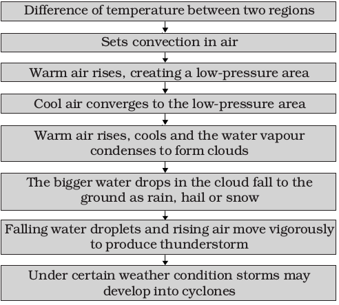
You know that water requires heat when it changes from liquid to vapour state. Does the water give back heat when vapour condenses into liquid? Can yourecall any experience to support this?
| Structure of a cyclone |
The centre of a cyclone is a calm area. It is called the eye of the storm. A large cyclone is a violently rotating mass of air in the atmosphere, 10 to 15 km high. The diameter of the eye varies from 10 to 30 km (Fig. 8.11). It is a region free of clouds and has light winds. Around this calm and clear eye (Fig. 8.12), there is a cloud region of about 150 km in size. In this region there are high-speed winds (150–250 km/h) and thick clouds with heavy rain. Away from this region the wind speed gradually decreases. The formation of a cyclone is a very complex process. A model is shown in Fig. 8.11. |
Before cloud formation, water takes up heat from the atmosphere to change into vapour. When water vapour changes back to liquid form as raindrops, this heat is released to the atmosphere. The heat released to the atmosphere warms the air around. The air tends to rise and causes a drop in pressure. More air rushes to the centre of the storm. This cycle is repeated. The chain of events ends with the formation of a very low-pressure system with very high-speed winds revolving around it. It is this weather condition that we call a cyclone. Factors like wind speed, wind direction, temperature and humidity contribute to the development of cyclones.

Fig. 8.11 Formation of a cyclone
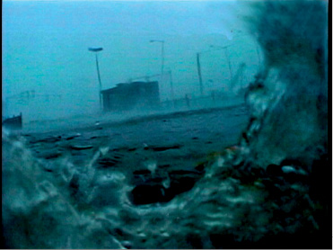
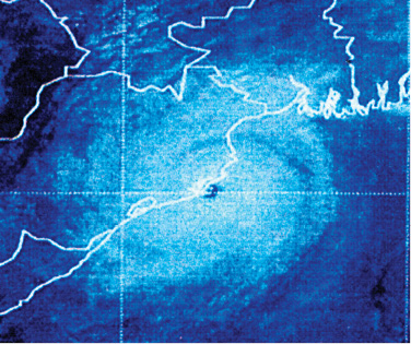
Fig. 8.13 Rising water caused by a cyclone.
Courtesy: India Meteorological Department, New Delhi
8.6 Destruction caused by cyclones
Cyclones can be very destructive. Strong winds push water towards the shore even if the storm is hundreds of kilometres away. These are the first indications of an approaching cyclone. The water waves produced by the wind are so powerful that a person cannot overcome them.
Continuous heavy rainfall may further worsen the flood situation.
High-speed winds accompanying a cyclone can damage houses, telephones and other communication systems, trees, etc., causing tremendous loss of life and property.
A cyclone is known by different names in different parts of the world. It is called a ‘hurricane’ in the American continent. In Philippines and Japan it is called a ‘typhoon’ (Fig. 8.14). |

Fig. 8.14 Regions near the equator where cyclones form. Cyclones are worldwide phenomena.

8.7 Effective safety measures
- A cyclone forecast and warning service.
- Rapid communication of warnings to the Government agencies, the ports, fishermen, ships and to the general public.
- Construction of cyclone shelters in the cyclone prone areas, and Administrative arrangements for moving people fast to safer places.
![08_16.tif]()
Courtesy: India Meteorological Department, New Delhi
We have learnt that all storms are low-pressure systems. Wind speed plays an important role in the formation of storms. It is, therefore, important to measure the wind speed. The instrument that measures the wind speed is called an anemometer. 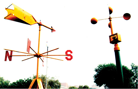 Fig. 8.17 An anemometer for measuring the speed of wind Courtesy: India Meteorological Department, New Delhi |
Action on the part of the people
- We should not ignore the warnings issued by the meteorological department through TV, radio, or newspapers.
- We should —
make necessary arrangements to shift the essential household goods, domestic animals and vehicles, etc. to safer places;
avoid driving on roads through standing water, as floods may have damaged the roads; and
keep ready the phone numbers of all emergency services like police, fire brigade, and medical centres.
Some other precautions, if you are staying in a cyclone hit area —
- Do not drink water that could be contaminated. Always store drinking water for emergencies.
- Do not touch wet switches and fallen power lines.
- Do not go out just for the sake of fun.
- Do not pressurise the rescue force by making undue demands.
- Cooperate and help your neighbours and friends.
8.8 Advanced technology has Helped
These days we are better protected. In the early part of the last century, coastal residents may have had less than a day to prepare or evacuate their homes from an oncoming cyclone. The world today is very different. Thanks to satellites and radars, a Cyclone alert or Cyclonewatch is issued 48 hours in advance of any expected storm and a Cyclone warning is issued 24 hrs in advance. The message is broadcast every hour or half hour when a cyclone is nearer the coast. Several national and international organisations cooperate to monitor the cyclone-related disasters.
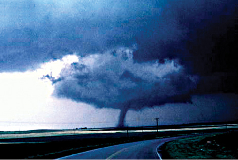
The diameter of a tornado can be as small as a metre and as large as a km, or even wider. The funnel of a tornado sucks dust, debris and everything near it at the base (due to low pressure) and throws them out near the top. Here are a few accounts of the survivors of tornados- (from Discovery channel’s “Young Discovery Series”).
“I saw the cloud coming and tried to take shelter inside. But as soon as I reached for the doorknob, the house took off into the sky. I was not hurt at all.”
“After the storm we had to clean the debris from the wheat fields. We picked up splintered boards and tree branches as well as dead chickens with their feathers blown off and rabbits looked like they had been skinned.”
A tornado shelter is a room situated deep inside or underground having no windows. Or otherwise it is better to shut windows and take shelter under a table, workbench, where debris cannot reach. One has to bow down on knees protecting head and neck using arms (Fig. 8.15).
| S.No. | Name | Pulse Per Minute |
| 1 | ||
| 2 | ||
| 3 | ||
| 4 | ||
| 4 |
| What you have learnt |
|
Exercises
1. Fill the missing word in the blank spaces in the following statements:
(a) Wind is——————air.
(b) Winds are generated due to——————heating on the earth.
(c) Near the earth’s surface __________air rises up whereas ___________ air comes down.
(d) Air moves from a region of ——— pressure to a region of——— pressure.
2. Suggest two methods to find out wind direction at a given place.
3. State two experiences that made you think that air exerts pressure (other than those given in the text).
4. You want to buy a house. Would you like to buy a house having windows but no ventilators? Explain your answer.
5. Explain why holes are made in hanging banners and hoardings.
6. How will you help your neighbours in case cyclone approaches your village/town?
7. What planning is required in advance to deal with the situation created by a cyclone?
8. Which one of the following place is unlikely to be affected by a cyclone.
(i) Chennai (ii) Mangaluru (Mangalore)
(iii) Amritsar (iv) Puri
9. Which of the statements given below is correct?
(i) In winter the winds flow from the land to the ocean.
(ii) In summer the winds flow from the land towards the ocean.
(iii) A cyclone is formed by a very high-pressure system with very
high-speed winds revolving around it.
(iv) The coastline of India is not vulnerable to cyclones.
Extended Learning — Activities and Projects
1. You can perform the Activity 8.5 in the chapter slight differently at home. Use two plastic bottles of the same size. Stretch one balloon on the neck of each bottle. Keep one bottle in the sun and the other in the shade. Record your observations. Compare these
observations and the result with those of Activity 8.5.
2. You can make your own anemometer.
Collect the following items:
4 small paper cups (used ice cream cups), 2 strips of cardboard (20cm long and 2cm wide), gum, stapler, a sketch pen and a sharpened pencil with eraser at one end.
Take a scale; draw crosses on the cardboard strips as shown in the
Fig. 8.18. This will give you the centres of the strips.
Fig. 8.18 Finding centre of the strips

Fig. 8.19 A model of an anemometer
Fix the strips at the centre, putting one over the other so that they make a plus (+) sign. Now fix the cups at the ends of the strips. Colour the outer surface of one cup with a marker or a sketch pen. All the 4 cups should face in the same direction.
Push a pin through the centre of the strips and attach the strips and the cups to the eraser of the pencil. Check that the strips rotate freely when you blow on the cups. Your anemometer is ready. Counting the number of rotations per minute will give you an estimate of the speed of the wind. To observe the changes in the wind speed, use it at different places and different times of the day.
If you do not have a pencil with attached eraser you can use the tip of a ball pen. The only condition is that the strips should rotate freely.
Remember that this anemometer will indicate only speed changes. It will not give you the actual wind speed.
3. Collect articles and photographs from newspapers and magazines about storms and cyclones. Make a story on the basis of what you learnt in this chapter and the matter collected by you.
4. Suppose you are a member of a committee, which is responsible for creating development plan of a coastal state. Prepare a short speech indicating the measures to be taken to reduce the suffering of the people caused by cyclones.
5. Interview eyewitness to collect the actual experience of people affected by a cyclone.
6. Take an aluminium tube about 15 cm long and 1 to 1.5 cm in diameter. Cut slice of a medium-sized potato about 2 cm thick. Insert the tube in the slice, press it, and rotate it 2–3 times.
Remove the tube. You will find a piece of potato fixed in the tube like a
piston head. Repeat the same process with the other end of the tube. Now you have the tube with both ends closed by potato pieces with an air column in between. Take a pencil with one end unsharpened. Place this end at one of the pieces of potato. Press it suddenly to push the potato piece in the tube. Observe what happens. The activity shows rather dramatically how increased air pressure can push things.
| CAUTION: When you perform this activity, make sure that nobody is standing in front of the tube. |

Fig. 8.20
You can read more on the related topics on the following website:
http://www.imd.gov.in/
| Did you know? |
A bolt of lightning travels at a speed of more than 400,000 km/h. It can heat the air around it to a temperature which is more than 4 times the temperature of the surface of the sun. That is what makes lightning so dangerous. |