Table of Contents


Renuka was excited. Shrikant Uncle was home after a gap of nearly four months. He was a wildlife photographer and travelled widely. Renuka’s interest in wildlife and forests began at an early age, when her uncle introduced her to books on nature. Pictures of distant lands and people, who lived there, always fascinated her.
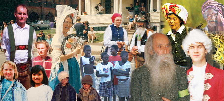
Fig. 8.1: People from various parts of the world
“In these pictures Renuka, you can see people from different parts of the world – some from dry deserts, some from frozen lands and some from hot wet rainforests.” “They look so different from me”, observed Renuka. “They may look different, but they share the same basic needs of life – food, clothing and shelter”, explained Shrikant Uncle. “Their children do the same things as you probably do, play games, quarrel sometimes and then make-up, sing, dance and help the families with various things that need to be done. They live closer to nature and very early in their lives have learnt to care for nature. They learn how to catch fish and how to collect material from the forests.”
In Chapters 8, 9 and 10, you will learn about the life of people in the different natural regions of the world.
Life in the Amazon Basin
Before learning about the Amazon basin, let us look at the map (Fig. 8.2). Notice that the tropical region lies very close to the equator; between 10°N and 10°S. So, it is referred to as the equatorial region. The river Amazon flows through this region. Notice how it flows from the mountains to the west and reaches the Atlantic Ocean to the east.
Do you know?
When Spanish explorers discovered the Amazon river, they were attacked by a group of local tribes wearing headgears and grass skirts. These people reminded them of the fierce tribes of women warriors known in ancient Roman
Empire as the Amazons. Hence the name Amazon.
The place where a river flows into another body of water is called the river’s mouth. Numerous tributaries join the Amazon River to form the Amazon basin. The river basin drains portions of Brazil, parts of Peru, Bolivia, Ecuador, Columbia and a small part of Venezuela.
Glossary
Tributaries: These are small rivers that join the main river. The main river along with all its tributaries that drain an area forms a river basin or the catchment area. The Amazon Basin is the largest river basin in the world.
Name the countries of the basin through which the equator passes.

Fig. 8.2: The Amazon Basin in South America
Climate
As you now know, the Amazon Basin stretches directly on the equator and is characterized by hot and wet climate throughout the year. Both day and nights are almost equally hot and humid. The skin feels sticky. It rains almost everyday, that too without much warning. The day temperatures are high with very high humidity. At night the temperature goes down but the humidity remains high.
Rainforests
As it rains heavily in this region, thick forests grow (Fig. 8.3). The forests are in fact so thick that the dense “roof” created by leaves and branches does not allow the sunlight to reach the ground. The ground remains dark and damp. Only shade tolerant vegetation may grow here. Orchids, bromeliads grow as plant parasites.

Fig. 8.3 : The Amazon Forest
The rainforest is rich in fauna. Birds such as toucans (Fig. 8.4), humming birds, bird of paradise with their brilliantly coloured plumage, oversized bills for eating make them different from birds we commonly see in India. These birds also make loud sounds in the forests. Animals like monkeys, sloth and ant-eating tapirs are found here (Fig. 8.5). Various species of reptiles and snakes also thrive in these jungles. Crocodiles, snakes, pythons abound. Anaconda and boa constrictor are some of the species. Besides, the basin is home to thousands of species of insects. Several species of fishes including the flesh-eating Piranha fish is also found in the river. This basin is thus extraordinarily rich in the variety of life found there.
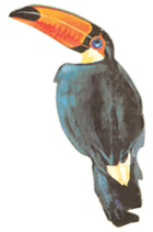
Fig. 8.4 : Toucans
Do you know?
Bromeliads are special plants that store water in their leaves. Animals like frogs use these pockets of water for laying their eggs.

Fig. 8.5 : Tapir
Some TV channels broadcast documentaries on the wildlife of the world. Try to watch some of the films and share your experience with the class.
People of the Rainforests
People grow most of their food in small areas after clearing some trees in the forest. While men hunt and fish along the rivers, women take care of the crops. They mainly grow tapioca, pineapple and sweet potato. As hunting and fishing are uncertain it is the women who keep their families alive by feeding them the vegetables they grow. They practice “slash and burn agriculture”. The staple food is manioc, also known as cassava that grows under the ground like the potato. They also eat queen ants and egg sacs. Cash crops like coffee, maize and cocoa are also grown.
The rainforests provide a lot of wood for the houses. Some families live in thatched houses shaped like beehives. There are other large apartment-like houses called “Maloca” with a steeply slanting roof.
Life of the people of the Amazon basin is slowly changing. In the older days the heart of the forest, could be reached only by navigating the river. In 1970 the Trans Amazon highway made all parts of the rainforest accessible. Aircrafts and helicopters are also used for reaching various places. The indigenous population was pushed out from the area and forced to settle in new areas where they continued to practice their distinctive way of farming.
Do you know?
Slash and Burn is a way of cultivating land where farmers clear a piece of land by slashing or cutting down trees and bushes. These are then burnt, which releases the nutrients into the soil. Now crops are grown in this cleared field for a few years.
After repeatedly using the patch of land, the soil looses its nutrients. So it is abandoned. Then they clear another plot of land to plant. In the mean time young trees grow in the old field. In this way soil fertility is restored. People can then return to it and start cultivating it again.
The developmental activities are leading to the gradual destruction of the biologically diverse rainforests. It is estimated that a large area of the rainforest has been disappearing annually in the Amazon basin. You can see that this destruction of forests has a much wider implication (Fig. 8.6). The topsoil is washed away as the rains fall and the lush forest turns into a barren landscape.

Fig. 8.6: Gradual Destruction of Forests
Life in the Ganga-Brahmaputra Basin
The tributaries of rivers Ganga and Brahmaputra together form the Ganga-Brahmaputra basin in the Indian subcontinent (Fig. 8.8). The basin lies in the sub-tropical region that is situated between 10°N to 30°N latitudes. The tributaries of the River Ganga like the Ghaghra, the Son, the Chambal, the Gandak, the Kosi and the tributaries of Brahmaputra drain it. Look at the atlas and find names of some tributaries of the River Brahmaputra.

Fig. 8.7 Brahmaputra river
The plains of the Ganga and the Brahmaputra, the mountains and the foothills of the Himalayas and the Sundarbans delta are the main features of this basin. Ox-bow lakes dot the plain area. The area is dominated by monsoon climate. The monsoon brings rains from mid-June to mid-September. The summers are hot and the winters cool.
.

Fig. 8.8: Ganga-Brahmputra Basin
River Brahmaputra is known by different names in difference places. Find the other names of the river.
Look at the map of India (Fig. 8.8). Find out the states in which the Ganga-Brahmputra basin lies.
The basin area has varied topography. The environment plays a dominant role in the distribution of the population. The mountain areas with steep slopes have inhospitable terrain. Therefore less number of people live in the mountain area of the Ganga-Brahmaputra basin. The plain area provides the most suitable land for human habitation. The soil is fertile. Agriculture is the main occupation of the people where flat land is available to grow crops. The density of population of the plains is very high. The main crop is paddy (Fig. 8.9). Since cultivation of paddy requires sufficient water, it is grown in the areas where the amount of rainfall is high
Activity
Collect some handicrafts made from jute, bamboo and silk. Display them in the class. Find out in which area they were made?
The vegetation cover of the area varies according to the type of landforms. In the Ganga and Brahmaputra plain tropical deciduous trees grow, along with teak, sal and peepal. Thick bamboo groves are common in the Brahmaputra plain. The delta area is covered with the mangrove forests. In parts of Uttarakhand, Sikkim and Arunachal Pradesh, coniferous trees like pine, deodar and fir can be seen because the climate is cool and the slopes are steep.

Fig. 8.9 : Paddy Cultivation

Fig. 8.10 : Tea Garden in Assam
There is a variety of wildlife in the basin. Elephants, tigers, deer and monkeys are common. The one-horned rhinoceros is found in the Brahmaputra plain. In the delta area, Bengal tiger, crocodiles and alligator are found. Aquatic life abounds in the fresh river waters, the lakes and the Bay of Bengal Sea. The most popular varieties of the fish are the rohu, catla and hilsa. Fish and rice is the staple diet of the people living in the area.

Fig. 8.11 : One horned rhinoceros

Fig. 8.12 : Crocodiles
Do you know?
Terraces are built on steep slopes to create flat surfaces on which crops are grown. The slope is removed so that water does not run off rapidly.

Terrace Farming
Do you know?
In the fresh waters of River Ganga and River Brahmaputra, a variety of dolphin locally called Susu (also called blind dolphin) is found. The presence of Susu is an indication of the health of the river. The untreated industrial and urban wastes with high amount of chemicals are killing this species.

Blind Dolphin
Lake: A source of livelihood
(A case study)

A clean lake
Binod is a fisherman living in the Matwali Maun village of Bihar. He is a happy man today. With the efforts of the fellow fishermen – Ravindar, Kishore, Rajiv and others, he cleaned the maun or the ox-bow lake to cultivate different varieties of fish. The local weed (vallineria, hydrilla) that grows in the lake is the food of the fish. The land around the lake is fertile. He sows crops such as paddy, maize and pulses in these fields. The buffalo is used to plough the land. The community is satisfied. There is enough fish catch from the river – enough fish to eat and enough fish to sell in the market. They have even begun supply to the neighbouring town. The community is living in harmony with nature. As long as the pollutants from nearby towns do not find their way into the lake waters, the fish cultivation will not face any threat.

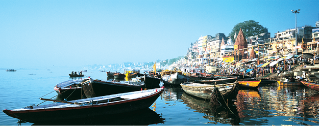
Fig. 8.13: Varanasi along the River Ganga

Fig. 8.14: Tiger in Manas Wildlife sanctuary
Do you know?
To conserve the river ganga, ‘Namami’ ganga Programme has been initiated

1. Answer the following questions.
(i) Name the continent in which the Amazon Basin is located.
(ii) What are the crops grown by the people of the Amazon Basin.
(iii) Name the birds that you are likely to find in the rainforests of the Amazon.
(iv) What are the major cities located on the River Ganga.
(v) Where is the one-horned rhinoceros found?
2. Tick the correct answer.
(i) Toucans are a type of
(a) birds (b) animals (c) crops
(ii) Manioc is the staple food of
(a) Ganga Basin (b) Africa (c) Amazon
(iii) Kolkata is located on the river
(a) Orange (b) Hooghly (c) Bhagirathi
(iv) Deodars and firs are a type of
(a) Coniferous trees (b) Deciduous trees (c) shrubs
(v) Bengal tiger is found in
(a) mountains (b) delta area (c) Amazon
3. Match the following.
(i) Cotton textile (a) Assam
(ii) Maloca (b) Terrace farming
(iii) Piranha (c) Sericulture
(iv) Silk worm (d) Slanting roof
(v) Kaziranga (e) Ganga plain
(f) Varanasi
(g) Fish
4. Give reasons.
(i) The rainforests are depleting.
(ii) Paddy is grown in the Ganga-Brahmaputra plains.
5. Map skills.
(i) On an outline map of the Indian Sub-continent, draw the rivers Ganga and Brahmaputra from the source to the mouth. Also show the important tributaries of both the rivers.
(ii) On the political map of South America, draw the equator. Mark the countries through which the equator passes.
6. For fun.
Make a collage to show places of attractions in India. You can divide the class in different groups to show attractions based on mountain landscapes, coastal beaches, wildlife sanctuaries and places of historical importance.
7. Activity.
Collect under mentioned material and observe how destruction of trees effect the soil cover.
Material
(i) Three small flowerpots or food cans (e.g., cold drinks tin cans),
(ii) one big can with holes punched in the bottom (this will act as a
sprinkling can),
(iii) twelve coins or bottle caps
(iv) soil.
Steps
Take three small cans or pots. Fill them with soil till the top. Press the soil to make it level with the top of the can. Now put four coins or bottle caps on the soil of each can. Take the big can that has been punched with holes and fill it with water. You can also take the sprinkling can from your garden. Now, sprinkle water on the three cans. On the first can sprinkle water very slowly so that no soil splashes out. Let moderate amount of water be sprinkled on the second can. On the third can, sprinkle the water heavily. You will observe that unprotected soil splashes out. Where the ‘rain’ is heavy the amount of soil that splashes out is the maximum and least in case of the first can. The coins or caps represent the tree covers. It is clear that if the land is cleared completely of the vegetation, the soil cover will quickly disappear.