Table of Contents
6
Colonialism and the City
The Story of an Imperial Capital
What Happened to Cities Under Colonial Rule?
You have seen how life in the countryside changed after the establishment of British power. What happened to the cities during the same period? The answer will depend on the kind of town or city we are discussing. The history of a temple town like Madurai will not be the same as that of a manufacturing town like Dacca, or a port like Surat, or towns that simultaneously served many different functions.
In most parts of the Western world modern cities emerged with industrialisation. In Britain, industrial cities like Leeds and Manchester grew rapidly in the nineteenth and twentieth centuries, as more and more people sought jobs, housing and other facilities in these places. However, unlike Western Europe, Indian cities did not expand as rapidly in the nineteenth century. Why was this so?
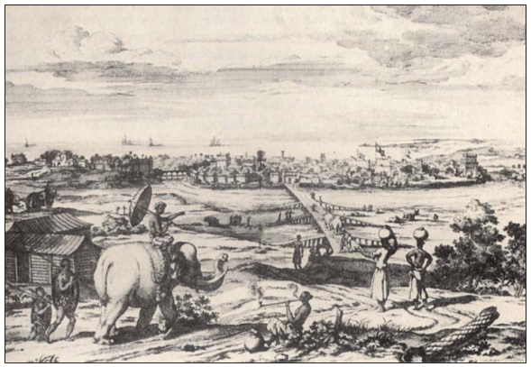
Fig. 1 – A view of Machlipatnam, 1672
Machlipatnam developed as an important port town in the seventeenth century. Its importance declined by the late eighteenth century as trade shifted to the new British ports of Bombay, Madras and Calcutta.
In the late eighteenth century, Calcutta, Bombay and Madras rose in importance as Presidency cities. They became the centres of British power in the different regions of India. At the same time, a host of smaller cities declined. Many towns manufacturing specialised goods declined due to a drop in the demand for what they produced. Old trading centres and ports could not survive when the flow of trade moved to new centres. Similarly, earlier centres of regional power collapsed when local rulers were defeated by the British and new centres of administration emerged. This process is often described as de-urbanisation. Cities such as Machlipatnam, Surat and Seringapatam were de-urbanised during the nineteenth century. By the early twentieth century, only 11 per cent of Indians were living in cities.
Presidency – For administrative purposes, colonial India was divided into three “Presidencies” (Bombay, Madras and Bengal), which developed from the East India Company’s “factories” (trading posts) at Surat, Madras and Calcutta.
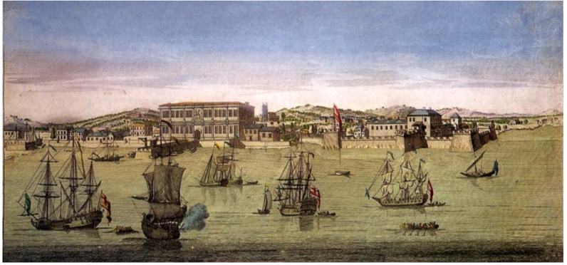
Fig. 2 – Bombay port in the eighteenth century
The city of Bombay began to grow when the East India Company started using Bombay as its main port in western India.
The historic imperial city of Delhi became a dusty provincial town in the nineteenth century before it was rebuilt as the capital of British India after 1912. Let us look at the story of Delhi to see what happened to it under colonial rule.
How many ‘Delhis’ before New Delhi?
You know Delhi as the capital of modern India. Did you also know that it has been a capital for more than a 1,000 years, although with some gaps? As many as 14 capital cities were founded in a small area of about 60 square miles on the left bank of the river Jamuna. The remains of all other capitals may be seen on a visit to the modern city-state of Delhi. Of these, the most important are the capital cities built between the twelfth and seventeenth centuries.
Urbanisation– The process by which more and more people begin to reside in towns and cities
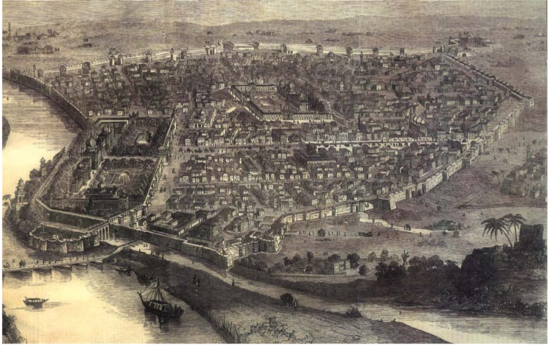
Fig. 3 – Image of Shahjahanabad in the mid-nineteenth century, The Illustrated London News,16 January 1858
You can see the Red Fort on the left. Notice the walls that surround the city. Through the centre runs the main road of Chandni Chowk. Note also the river Jamuna is flowing near the Red Fort. Today it has shifted course. The place where the boat is about to embank is now known as Daryaganj (darya means river, ganj means market)
Dargah – The tomb of a Sufi saint
Khanqah – A sufi lodge, often used as a rest house for travellers and a place where people come to discuss spiritual matters, get the blessings of saints, and hear sufi music
Idgah – An open prayer place of Muslims primarily meant for id prayers
Cul-de-sac – Street with a dead end
The most splendid capital of all was built by Shah Jahan. Shahjahanabad was begun in 1639 and consisted of a fort-palace complex and the city adjoining it. Lal Qila or the Red Fort, made of red sandstone, contained the palace complex. To its west lay the Walled City with 14 gates. The main streets of Chandni Chowk and Faiz Bazaar were broad enough for royal processions to pass. A canal ran down the centre of Chandni Chowk.
Set amidst densely packed mohallas and several dozen bazaars, the Jama Masjid was among the largest and grandest mosques in India. There was no place higher than this mosque within the city then.
Delhi during Shah Jahan’s time was also an important centre of Sufi culture. It had several dargahs, khanqahs and idgahs. Open squares, winding lanes, quiet cul-de-sacs and water channels were the pride of Delhi’s residents. No wonder the poet Mir Taqi Mir said, “The streets of Delhi aren’t mere streets; they are like the album of a painter.”
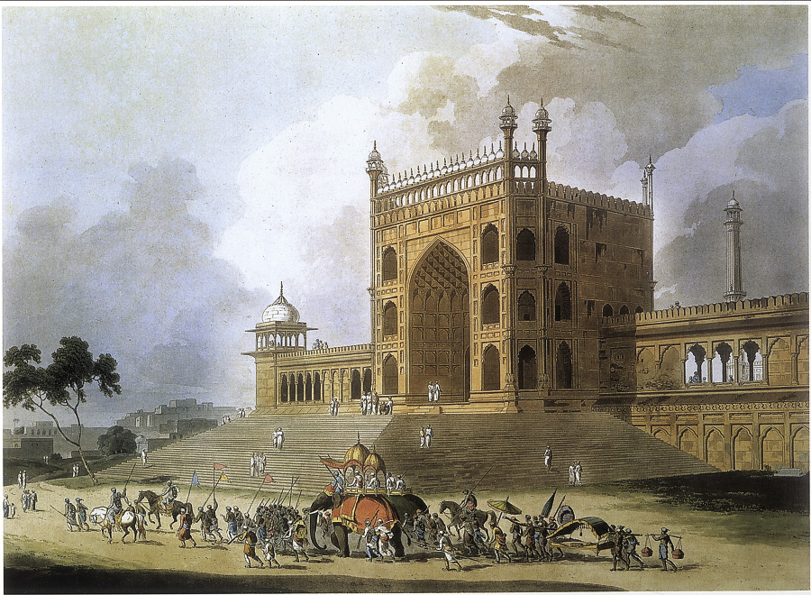
Fig. 4 – The eastern gate of the Jama Masjid in Delhi, by Thomas Daniell, 1795
This is also the first mosque in India with minarets and full domes.
Yet, even this was no ideal city, and its delights were enjoyed only by some. There were sharp divisions between rich and poor. Havelis or mansions were interspersed with the far more numerous mud houses of the poor. The colourful world of poetry and dance was usually enjoyed only by men. Furthermore, celebrations and processions often led to serious conflicts.
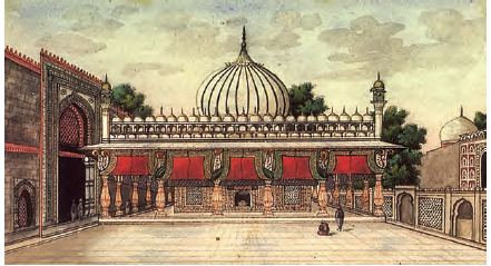
Fig. 5 – The shrine of Nizamuddin Auliya in Delhi
Source 1
“Dilli jo ek shahr tha alam mein intikhab...”
By 1739, Delhi had been sacked by Nadir Shah and plundered many times. Expressing the sorrow of those who witnessed the decline of the city, the eighteenth-century Urdu poet Mir Taqi Mir, said:
Dilli jo ek shahr tha alam mein intikhab,
...
Ham rahne wale hain usi ujre dayar ke
(I belong to the same ruined territory of Delhi, which was once a supreme city in the world)
The Making of New Delhi
In 1803, the British gained control of Delhi after defeating the Marathas. Since the capital of British India was Calcutta, the Mughal emperor was allowed to continue living in the palace complex in the Red Fort. The modern city as we know it today developed only after 1911 when Delhi became the capital of British India.
Demolishing a past
Before 1857, developments in Delhi were somewhat different from those in other colonial cities. In Madras, Bombay or Calcutta, the living spaces of Indians and the British were sharply separated. Indians lived in the “black” areas, while the British lived in well-laid- out “white” areas. In Delhi, especially in the first half of the nineteenth century, the British lived along with the wealthier Indians in the Walled City. The British learned to enjoy Urdu/Persian culture and poetry and participated in local festivals.
Gulfaroshan – A festival of flowers
Renaissance – Literally, rebirth of art and learning. It is a term often used to describe a time when there is great creative activity.
The establishment of the Delhi College in 1792 led to a great intellectual flowering in the sciences as well as the humanities, largely in the Urdu language. Many refer to the period from 1830 to 1857 as a period of the Delhi renaissance.
All this changed after 1857. During the Revolt that year, as you have seen, the rebels gathered in the city, and persuaded Bahadur Shah to become the leader of the uprising. Delhi remained under rebel control for four months.
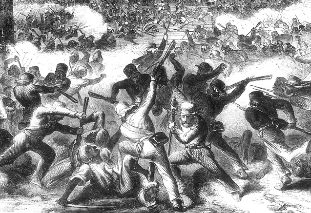
Fig. 6 – British forces wreaking vengeance on the streets of Delhi, massacring the rebels.
Source 2 :
“There was once a city of this name”
Ghalib lamented the changes that were occurring and wrote sadly about the past that was lost. He wrote:
What can I write? The life of Delhi depends on the Fort, Chandni Chowk, the daily gatherings at the Jamuna Bridge and the Annual Gulfaroshan. When all these … things are no longer there, how can Delhi live? Yes, there was once a city of this name in the dominions of India.
When the British regained the city, they embarked on a campaign of revenge and plunder. The famous poet Ghalib witnessed the events of the time. This is how he described the ransacking of Delhi in 1857: “When the angry lions (the British) entered the town, they killed the helpless … and burned houses. Hordes of men and women, commoners and noblemen, poured out of Delhi from the three gates and took shelter in small communities, and tombs outside the city.” To prevent another rebellion, the British exiled Bahadur Shah to Burma (now Myanmar), dismantled his court, razed several of the palaces, closed down gardens and built barracks for troops in their place.
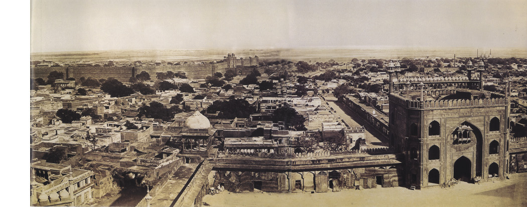
Fig. 7 – Looking out from Jama Masjid, photograph by Felice Beato, 1858-59
Notice the buildings all around the Masjid. They were cleared after the Revolt of 1857
The British wanted Delhi to forget its Mughal past. The area around the Fort was completely cleared of gardens, pavilions and mosques (though temples were left intact). The British wanted a clear ground for security reasons. Mosques in particular were either destroyed, or put to other uses. For instance, the Zinat-al-Masjid was converted into a bakery. No worship was allowed in the Jama Masjid for five years. One-third of the city was demolished, and its canals were filled up.
In the 1870s, the western walls of Shahjahanabad were broken to establish the railway and to allow the city to expand beyond the walls. The British now began living in the sprawling Civil Lines area that came up in the north, away from the Indians in the Walled City. The Delhi College was turned into a school, and shut down in 1877.
Fig. 8 – View from the Jama Masjid after the surrounding buildings were demolished
.
Activity
Compare the view in Fig. 8 with that in Fig. 7. Write a paragraph on what the changes depicted in the pictures might have meant to people living in the area.
Planning a new capital
The British were fully aware of the symbolic importance of Delhi. After the Revolt of 1857, many spectacular events were held there. In 1877, Viceroy Lytton organised a Durbar to acknowledge Queen Victoria as the Empress of India. Remember that Calcutta was still the capital of British India, but the grand Durbar was being held in Delhi. Why was this so? During the Revolt, the British had realised that the Mughal emperor was still important to the people and they saw him as their leader. It was therefore important to celebrate British power with pomp and show in the city the Mughal emperors had earlier ruled, and the place which had turned into a rebel stronghold in 1857.
In 1911, when King George V was crowned in England, a Durbar was held in Delhi to celebrate the occasion. The decision to shift the capital of India from Calcutta to Delhi was announced at this Durbar.
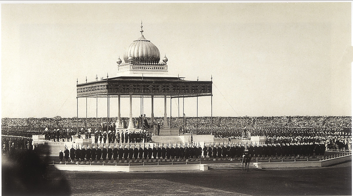
Fig. 9 – The Coronation Durbar of King George V, 12 December, 1911
Over 100,000 Indian princes and British officers and soldiers gathered at the Durbar.
New Delhi was constructed as a 10-square-mile city on Raisina Hill, south of the existing city. Two architects, Edward Lutyens and Herbert Baker, were called on to design New Delhi and its buildings. The government complex in New Delhi consisted of a two-mile avenue, Kingsway (now Rajpath), that led to the Viceroy’s Palace (now Rashtrapati Bhavan), with the Secretariat buildings on either sides of the avenue. The features of these government buildings were borrowed from different periods of India’s imperial history, but the overall look was Classical Greece (fifth century bce). For instance, the central dome of the Viceroy’s Palace was copied from the Buddhist stupa at Sanchi, and the red sandstone and carved screens or jalis were borrowed from Mughal architecture. But the new buildings had to assert British importance: that is why the architect made sure that the Viceroy’s Palace was higher than Shah Jahan’s Jama Masjid!
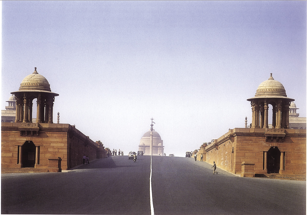
Fig. 10 – The Viceregal Palace (Rashtrapati Bhavan) atop Raisina Hill
Activity
Imagine yourself walking up Raisina Hill, looking towards Rashtrapati Bhavan. Do you think Baker was right in thinking that looking up to the building would create a sense of awe and emphasise the power of the British?
How was this to be done?
New Delhi took nearly 20 years to build. The idea was to build a city that was a stark contrast to Shahjahanabad. There were to be no crowded mohallas, no mazes of narrow bylanes. In New Delhi, there were to be broad, straight streets lined with sprawling mansions set in the middle of large compounds. The architects wanted New Delhi to represent a sense of law and order, in contrast to the chaos of Old Delhi. The new city also had to be a clean and healthy space. The British saw overcrowded spaces as unhygienic and unhealthy, the source of disease. This meant that New Delhi had to have better water supply, sewage disposal and drainage facilities than the Old City. It had to be green, with trees and parks ensuring fresh air and adequate supply of oxygen.
Source 3 :
The vision of New Delhi
This is how Viceroy Hardinge explained the choice of Delhi as capital:
The change would strike the imagination of the people of India … and would be accepted by all as the assertion of an unfaltering determination to maintain British rule in India.
The architect Herbert Baker believed:
The New Capital must be the sculptural monument of the good government and unity which India, for the first time in its history, has enjoyed under British rule. British rule in India is not a mere veneer of government and culture. It is a new civilisation in growth, a blend of the best elements of East and West … It is to this great fact that the architecture of Delhi should bear testimony. (2 October 1912)
Activity
Can you find at least two instances from this chapter that suggest that there were other ways of thinking about the image of the capital city?
Life in the time of Partition
The Partition of India in 1947 led to a massive transfer of populations on both sides of the new border. As a result, the population of Delhi swelled, the kinds of jobs people did changed, and the culture of the city became different.
Days after Indian Independence and Partition, fierce rioting began. Thousands of people in Delhi were killed and their homes looted and burned. As streams of Muslims left Delhi for Pakistan, their place was taken by equally large numbers of Sikh and Hindu refugees from Pakistan. Refugees roamed the streets of Shahjahanabad, searching for empty homes to occupy. At times they forced Muslims to leave or sell their properties. Over two-thirds of the Delhi Muslims migrated, almost 44,000 homes were abandoned. Terrorised Muslims lived in makeshift camps till they could leave for Pakistan.
At the same time, Delhi became a city of refugees. Nearly 500,000 people were added to Delhi’s population (which had a little over 800,000 people in 1951). Most of these migrants were from Punjab. They stayed in camps, schools, military barracks and gardens, hoping to build new homes. Some got the opportunity to occupy residences that had been vacated; others were housed in refugee colonies. New colonies such as Lajpat Nagar and Tilak Nagar came up at this time. Shops and stalls were set up to cater to the demands of the migrants; schools and colleges were also opened.
The skills and occupations of the refugees were quite different from those of the people they replaced. Many of the Muslims who went to Pakistan were artisans, petty traders and labourers. The new migrants coming to Delhi were rural landlords, lawyers, teachers, traders and small shopkeepers. Partition changed their lives, and their occupations. They had to take up new jobs as hawkers, vendors, carpenters and ironsmiths. Many, however, prospered in their new businesses.
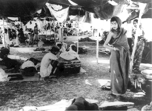
Fig. 11 – Thousands stayed in the refugee camps set up in Delhi after Partition.
The large migration from Punjab changed the social milieu of Delhi. An urban culture largely based on Urdu was overshadowed by new tastes and sensibilities, in food, dress and the arts.
Inside the Old City
Meanwhile, what happened to the old city, that had been Shahjahanabad? In the past, Mughal Delhi’s famed canals had brought not only fresh drinking water to homes, but also water for other domestic uses. This excellent system of water supply and drainage was neglected in the nineteenth century. The system of wells (or baolis) also broke down, and channels to remove household waste (called effluents) were damaged. This was at a time when the population of the city was continuously growing.
The broken-down canals could not serve the needs of this rapidly increasing population. At the end of the nineteenth century, the Shahjahani drains were closed and a new system of open surface drains was introduced. This system too was soon overburdened, and many of the wealthier inhabitants complained about the stench from roadside privies and overflowing open drains. The Delhi Municipal Committee was unwilling to spend money on a good drainage system.
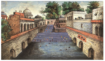
Fig. 12 – A famous baoli near the shrine of Nizamuddin Auliya in Delhi
At the same time, though, millions of rupees were being spent on drainage systems in the New Delhi area.
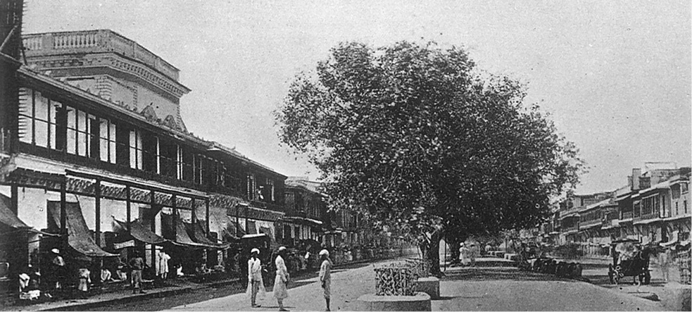
Fig. 13 – Chandni Chowk in Delhi in the late nineteenth century
The decline of havelis
The Mughal aristocracy in the seventeenth and eighteenth centuries lived in grand mansions called havelis. A map of the mid-nineteenth century showed at least a hundred such havelis, which were large walled compounds with mansions, courtyards and fountains.
A haveli housed many families. On entering the haveli through a beautiful gateway, you reached an open courtyard, surrounded by public rooms meant for visitors and business, used exclusively by males. The inner courtyard with its pavilions and rooms was meant for the women of the household. Rooms in the havelis had multiple uses, and very little by way of furniture.
Activity
Think of the life of two young people – one growing up in a haveli and the other in a colonial bungalow. What would be the difference in their relationship with the family? Which would you prefer to live in? Discuss your views with your classmates, and give reasons for your choice.
Even in the mid-nineteenth century Qamr-al-din Khan’s haveli had several structures within it, and included housing for the cart drivers, tent pitchers, torchbearers, as well as for accountants, clerks and household servants.
Many of the Mughal amirs were unable to maintain these large establishments under conditions of British rule. Havelis therefore began to be subdivided and sold. Often the street front of the havelis became shops or warehouses. Some havelis were taken over by the upcoming mercantile class, but many fell into decay and disuse.
Amir – A nobleman
The colonial bungalow was quite different from the haveli. Meant for one nuclear family, it was a large single-storeyed structure with a pitched roof, and usually set in one or two acres of open ground. It had separate living and dining rooms and bedrooms, and a wide veranda running in the front, and sometimes on three sides. Kitchens, stables and servants’ quarters were in a separate space from the main house. The house was run by dozens of servants. The women of the household often sat on the verandas to supervise tailors or other tradesmen.
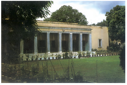
Fig. 14 – A colonial bungalow in New Delhi
The Municipality begins to plan
The census of 1931 revealed that the walled city area was horribly crowded with as many as 90 persons per acre, while New Delhi had only about 3 persons per acre.
The poor conditions in the Walled City, however, did not stop it from expanding. In 1888 an extension scheme called the Lahore Gate Improvement Scheme was planned by Robert Clarke for the Walled City residents. The idea was to draw residents away from the Old City to a new type of market square, around which shops would be built. Streets in this redevelopment strictly followed the grid pattern, and were of identical width, size and character. Land was divided into regular areas for the construction of neighbourhoods. Clarkegunj, as the development was called, remained incomplete and did not help to decongest the Old City. Even in 1912, water supply and drainage in these new localities was very poor.
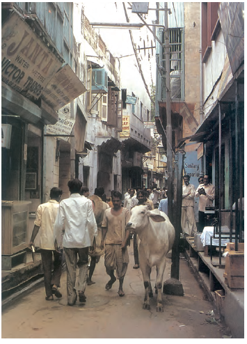
Fig. 15 – A street in Old Delhi
The Delhi Improvement Trust was set up 1936, and it built areas like Daryaganj South for wealthy Indians. Houses were grouped around parks. Within the houses, space was divided according to new rules of privacy. Instead of spaces being shared by many families or groups, now different members of the same family had their own private spaces within the home.
Imagine that you are a young man living in Shahjahanabad in 1700. Based on the description of the area in this chapter, write an account of your activities during one day of your life.
Let’s recall
1. State whether true or false:
(a) In the Western world, modern cities grew with industrialisation.
(b) Surat and Machlipatnam developed in the nineteenth century.
(c) In the twentieth century, the majority of Indians lived in cities.
(d) After 1857 no worship was allowed in the Jama Masjid for five years.
(e) More money was spent on cleaning Old Delhi than New Delhi.
2. Fill in the blanks:
(a) The first structure to successfully use the dome was called the _____________.
(b) The two architects who designed New Delhi and Shahjahanabad were _____________ and _____________.
(c) The British saw overcrowded spaces as _____________.
(d) In 1888 an extension scheme called the _____________ was devised.
3. Identify three differences in the city design of New Delhi and Shahjahanabad.
4. Who lived in the “white” areas in cities such as Madras?
Let’s discuss
5. What is meant by de-urbanisation?
6. Why did the British choose to hold a grand Durbar in Delhi although it was not the capital?
7. How did the Old City of Delhi change under British rule?
8. How did the Partition affect life in Delhi?
Let’s do
9. Find out the history of the town you live in or of any town nearby. Check when and how it grew, and how it has changed over the years. You could look at the history of the bazaars, the buildings, cultural institutions, and settlements.
10. Make a list of at least ten occupations in the city, town or village to which you belong, and find out how long they have existed. What does this tell you about the changes within this area?