Table of Contents
Unit III
Climate, Vegetation
This unit deals with
- Weather and climate – spatial and temporal distribution of temperature, pressure, winds and rainfall; Indian monsoons: mechanism, onset and variability – spatial and temporal; climatic types
- Natural vegetation – forest types and distribution; wild life conservation; biosphere reserves

Chapter 4
Climate
We drink more water during summers. Your uniform during the summer is different from the winters. Why do you wear lighter clothes during summers and heavy woollen clothes during winters in north India? In southern India, woollen clothes are not required. In northeastern states, winters are mild except in the hills. There are variations in weather conditions during different seasons. These changes occur due to the changes in the elements of weather (temperature, pressure, wind direction and velocity, humidity and precipitation, etc.).
Weather is the momentary state of the atmosphere while climate refers to the average of the weather conditions over a longer period of time. Weather changes quickly, may be within a day or week but climate changes imperceptively and may be noted after 50 years or even more.
You have already studied about the monsoon in your earlier classes. You are also aware of the meaning of the word, “monsoon”. Monsoon connotes the climate associated with seasonal reversal in the direction of winds. India has hot monsoonal climate which is the prevalent climate in south and southeast Asia.
Unity and Diversity in the Monsoon Climate
The monsoon regime emphasises the unity of India with the rest of southeast Asian region. This view of broad unity of the monsoon type of climate should not, however, lead one to ignore its regional variations which differentiate the weather and climate of different regions of India. For example, the climate of Kerala and Tamil Nadu in the south are so different from that of Uttar Pradesh and Bihar in the north, and yet all of these have a monsoon type of climate. The climate of India has many regional variations expressed in the pattern of winds, temperature and rainfall, rhythm of seasons and the degree of wetness or dryness. These regional diversities may be described as sub-types of monsoon climate. Let us take a closer look at these regional variations in temperature, winds and rainfall.
While in the summer the mercury occasionally touches 55°°C in the western Rajasthan, it drops down to as low as minus 45°°C in winter around Leh. Churu in Rajasthan may record a temperature of 50°°C or more on a June day while the mercury hardly touches 19°°C in Tawang (Arunachal Pradesh) on the same day. On a December night, temperature in Drass (Ladakh) may drop down to minus 45°°C while Thiruvananthapuram or Chennai on the same night records 20°°C or 22°°C. These examples confirm that there are seasonal variations in temperature from place to place and from region to region in India. Not only this, if we take only a single place and record the temperature for just one day, variations are no less striking. In Kerala and in the Andaman Islands, the difference between day and night temperatures may be hardly seven or eight degree Celsius. But in the Thar desert, if the day temperature is around 50°°C, at night, it may drop down considerably upto 15°°-20°°C.
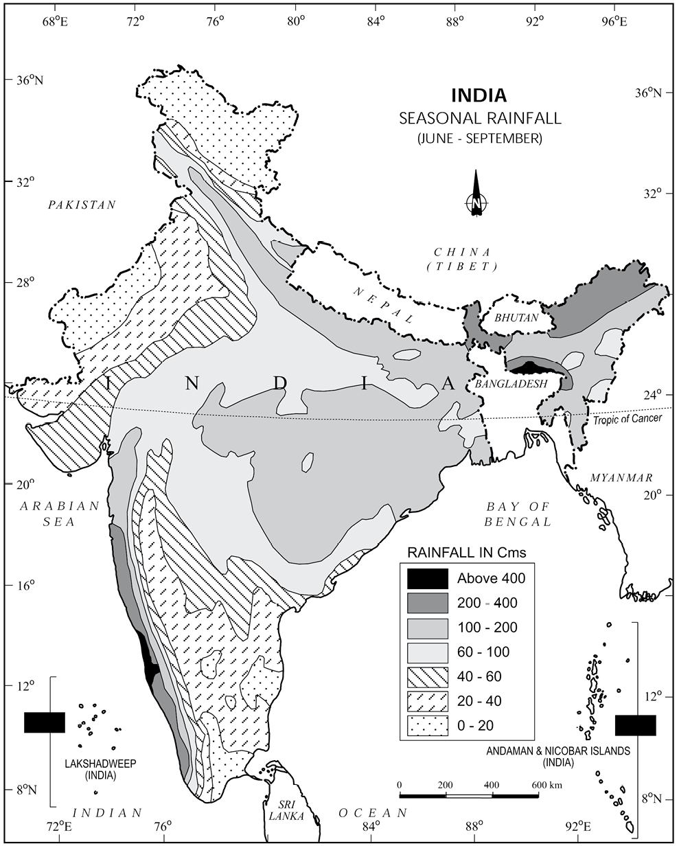
Now, let us see the regional variations in precipitation. While snowfall occurs in the Himalayas, it only rains over the rest of the country. Similarly, variations are noticeable not only in the type of precipitation but also in its amount. While Cherrapunji and Mawsynram in the Khasi Hills of Meghalaya receive rainfall over 1,080 cm in a year, Jaisalmer in Rajasthan rarely gets more than 9 cm of rainfall during the same period.
Tura situated in the Garo Hills of Meghalaya may receive an amount of rainfall in a single day which is equal to 10 years of rainfall at Jaisalmer. While the annual precipitation is less than 10 cm in the north�west Himalayas and the western deserts, it exceeds 400 cm in Meghalaya. The Ganga delta and the coastal plains of Odisha are hit by strong rain-bearing storms almost every third or fifth day in July and August while the Coromandal coast, a thousand km to the south, goes generally dry during these months. Most parts of the country get rainfall during June�September, but on the coastal areas of Tamil Nadu, it rains in the beginning of the winter season.
In spite of these differences and variations, the climate of India is monsoonal in rhythm and character.
Factors Determining the Climate of India
IIndia’s climate is controlled by a number of factors.
Factors related to Location and Relief
Latitude : You already know the latitudinal and longitudinal extent of the land of India. You also know that the Tropic of Cancer passes through the central part of India in east-west direction. Thus, northern part of the India lies in sub-tropical and temperate zone and the part lying south of the Tropic of Cancer falls in the tropical zone. The tropical zone being nearer to the equator, experiences high temperatures throughout the year with small daily and annual range. Area north of the Tropic of Cancer being away from the equator, experiences extreme climate with high daily and annual range of temperature.
The Himalayan Mountains : The lofty Himalayas in the north along with its extensions act as an effective climatic divide. The towering mountain chain provides an invincible shield to protect the subcontinent from the cold northern winds. These cold and chilly winds originate near the Arctic circle and blow across central and eastern Asia. The Himalayas also trap the monsoon winds, forcing them to shed their moisture within the subcontinent.
Distribution of Land and Water : India is flanked by the Indian Ocean on three sides in the south and girdled by a high and continuous mountain-wall in the north. As compared to the landmass, water heats up or cools down slowly. This differential heating of land and sea creates different air pressure zones in different seasons in and around the Indian subcontinent. Difference in air pressure causes reversal in the direction of monsoon winds.
Distance from the Sea : With a long coastline, large coastal areas have an equable climate. Areas in the interior of India are far away from the moderating influence of the sea. Such areas have extremes of climate. That is why, the people of Mumbai and the Konkan coast have hardly any idea of extremes of temperature and the seasonal rhythm of weather. On the other hand, the seasonal contrasts in weather at places in the interior of the country such as Delhi, Kanpur and Amritsar affect the entire sphere of life.
Altitude : With a long coastline, large coastal areas have an equable climate. Areas in the interior of India are far away from the moderating influence of the sea. Such areas have extremes of climate. That is why, the people of Mumbai and the Konkan coast have hardly any idea of extremes of temperature and the seasonal rhythm of weather. On the other hand, the seasonal contrasts in weather at places in the interior of the country such as Delhi, Kanpur and Amritsar affect the entire sphere of life.
Relief : The physiography or relief of India also affects the temperature, air pressure, direction and speed of wind and the amount and distribution of rainfall. The windward sides of Western Ghats and Assam receive high rainfall during June-September whereas the southern plateau remains dry due to its leeward situation along the Western Ghats.
Inter Tropical Convergence Zone (ITCZ)
The Inter Tropical Convergence Zone (ITCZ) is a low pressure zone located at the equator where trade winds converge, and so, it is a zone where air tends to ascend. In July, the ITCZ is located around 20°N-25°N latitudes (over the Gangetic plain), sometimes called the monsoon trough. This monsoon trough encourages the development of thermal low over north and northwest India. Due to the shift of ITCZ, the trade winds of the southern hemisphere cross the equator between 40° and 60°E longitudes and start blowing from southwest to northeast due to the Coriolis force. It becomes southwest monsoon. In winter, the ITCZ moves southward, and so the reversal of winds from northeast to south and southwest, takes place. They are called northeast monsoons.
THE NATURE OF INDIAN MONSOON
Monsoon is a familiar though a little known climatic phenomenon. Despite the observations spread over centuries, the monsoon continues to puzzle the scientists. Many attempts have been made to discover the exact nature and causation of monsoon, but so far, no single theory has been able to explain the monsoon fully. A real breakthrough has come recently when it was studied at the global rather than at regional level.
Systematic studies of the causes of rainfall in the South Asian region help to understand the causes and salient features of the monsoon, particularly some of its important aspects, such as:
(i) The onset of the monsoon.
(ii) Break in the monsoon.
Onset of the Monsoon
Towards the end of the nineteenth century, it
was believed that the differential heating of land and sea during the summer months is the mechanism which sets the stage for the monsoon winds to drift towards the subcontinent. During April and May when the sun shines vertically over the Tropic of Cancer, the large landmass in the north of Indian ocean gets intensely heated. This causes the formation of an intense low pressure in the northwestern part of the subcontinent. Since the pressure in the Indian Ocean in the south of the landmass is high as water gets heated slowly, the low pressure cell attracts the southeast trades across the Equator. These conditions help in the northward shift in the position of the ITCZ. The southwest monsoon may thus, be seen as a continuation of the southeast trades deflected towards the Indian subcontinent after crossing the Equator. These winds cross the Equator between 40°°E and 60°°E longitudes.
Figure 4.1 : Onset of Monsoon
CLIMATE
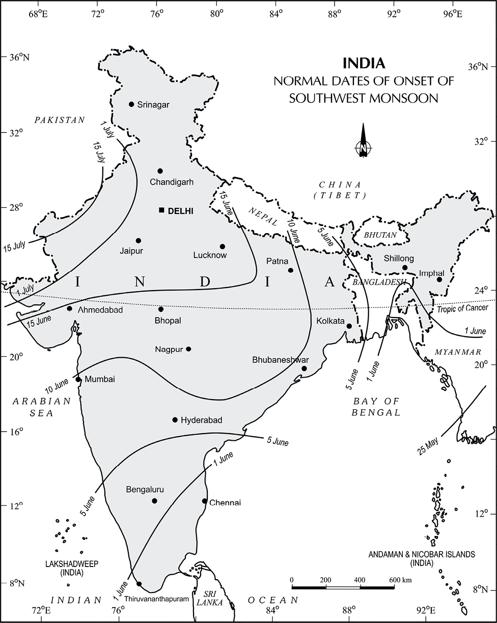
The shift in the position of the ITCZ is also related to the phenomenon of the withdrawal of the westerly jet stream from its position over the north Indian plain, south of the Himalayas. The easterly jet stream sets in along 15°°N latitude only after the western jet stream has withdrawn itself from the region. This easterly jet stream is held responsible for the burst of the monsoon in India. Entry of Monsoon into India : The southwest monsoon sets in over the Kerala coast by 1st June and moves swiftly to reach Mumbai and Kolkata between 10th and 13th June. By mid-July, southwest monsoon engulfs the entire subcontinent (Figure 4.2)
Break in the Monsoon
During the south-west monsoon period after having rains for a few days, if rain fails to occur for one or more weeks, it is known as break in the monsoon. These dry spells are quite common during the rainy season. These breaks in the different regions are due to different reasons:
(i) In northern India rains are likely to fail if the rain-bearing storms are not very frequent along the monsoon trough or the ITCZ over this region.
(ii) Over the west coast the dry spells are associated with days when winds blow parallel to the coast
THE RHYTHM OF SEASONS
The climatic conditions of India can best be described in terms of an annual cycle of seasons. The meteorologists recognise the following four seasons :
(i) the cold weather season
(ii) the hot weather season
(iii) the southwest monsoon season
(iv) the retreating monsoon season.
The Cold Weather Season
Temperature : Usually, the cold weather season sets in by mid-November in northern India. December and January are the coldest months in the northern plain. The mean daily temperature remains below 21°°C over most parts of northern India. The night temperature may be quite low, sometimes going below freezing point in Punjab and Rajasthan.
There are three main reasons for the excessive cold in north India during this season :
(i) States like Punjab, Haryana and Rajasthan being far away from the moderating influence of sea experience continental climate.
(ii) The snowfall in the nearby Himalayan ranges creates cold wave situation; and
(iii) Around February, the cold winds coming from the Caspian Sea and Turkmenistan
EI-Nino and the Indian Monsoon
EI-Nino is a complex weather system that appears once every three to seven years, bringing drought, floods and other weather extremes to different parts of the world.
The system involves oceanic and atmospheric phenomena with the appearance of warm currents off the coast of Peru in the Eastern Pacific and affects weather in many places including India. EI-Nino is merely an extension of the warm equatorial current which gets replaced temporarily by cold Peruvian current or Humbolt current (locate these currents in your atlas). This current increases the temperature of water on the Peruvian coast by 10°°C. This results in:
(i) the distortion of equatorial atmospheric circulation;
(ii) irregularities in the evaporation of sea water;
(iii) reduction in the amount of planktons which further reduces the number of fish in the sea.
The word EI-Nino means ‘Child Christ’ because this current appears around Christmas in December. December is a summer month in Peru (Southern Hemisphere).
EI-Nino is used in India for forecasting long range monsoon rainfall. In 1990-91, there was a wild EI-Nino event and the onset of southwest monsoon was delayed over most parts of the country ranging from five to twelve days.
![]()
Figure 4.2 : India : Normal Dates of Onset of the Southwest Monsoon
bring cold wave along with frost and fog over the northwestern parts of India.
Understanding the Monsoon
Attempts have been made to understand the nature and mechanism of the monsoon on the basis of data collected on land, oceans and in the upper atmosphere. The intensity of southwest monsoon winds of southern oscillation can be measured, among others, by measuring the difference in pressure between Tahiti (roughly 20°°S and 140°°W) in French Polynesia in East Pacific and port Darwin (12°°30'S and 131°°E) in northern Australia. Indian Meteorological Department (IMD) can forecast the possible behaviour of monsoons on the basis of 16 indicators.
Attempts have been made to understand the nature and mechanism of the monsoon on the basis of data collected on land, oceans and in the upper atmosphere. The intensity of southwest monsoon winds of southern oscillation can be measured, among others, by measuring the difference in pressure between Tahiti (roughly 20°°S and 140°°W) in French Polynesia in East Pacific and port Darwin (12°°30'S and 131°°E) in northern Australia. Indian Meteorological Department (IMD) can forecast the possible behaviour of monsoons on the basis of 16 indicators.
The Peninsular region of India, however, does not have any well-defined cold weather season. There is hardly any seasonal change in the distribution pattern of the temperature in coastal areas because of moderating influence of the sea and the proximity to equator. For example, the mean maximum temperature for January at Thiruvanantapuram is as high as 21°°C, and for June, it is 29.5°°C. Temperatures at the hills of Western Ghats remain comparatively low.
Pressure and Winds : By the end of December (22nd December), the sun shines vertically over the Tropic of Capricorn in the southern hemisphere. The weather in this season is characterised by feeble high pressure conditions over the northern plain. In south India, the air pressure is slightly lower. The isobars of 1019 mb and 1013 mb pass through northwest India and far south, respectively.
As a result, winds start blowing from northwestern high pressure zone to the low air pressure zone over the Indian Ocean in the south.
Due to low pressure gradient, the light winds with a low velocity of about 3-5 km per hour begin to blow outwards. By and large, the topography of the region influences the wind direction. They are westerly or northwesterly down the Ganga Valley. They become northerly in the Ganga-Brahmaputra delta. Free from the influence of topography, they are clearly northeasterly over the Bay of Bengal.
During the winters, the weather in India is pleasant. The pleasant weather conditions, however, at intervals, get disturbed by shallow cyclonic depressions originating over the east Mediterranean Sea and travelling eastwards across West Asia, Iran, Afghanistan and Pakistan before they reach the northwestern parts of India. On their way, the moisture content gets augmented from the Caspian Sea in the north and the Persian Gulf in the south. What is the role of Westerly Jet Streams in steering these depressions in India?
Pressure and Winds : The summer months are a period of excessive heat and falling air pressure in the northern half of the country. Because of the heating of the subcontinent, the ITCZ moves northwards occupying a position centred at 25°°N in July. Roughly, this elongated low pressure monsoon trough extends over the Thar desert in the north-west to Patna and Chotanagpur plateau in the east-southeast. The location of the ITCZ attracts a surface circulation of the winds which are southwesterly on the west coast as well as along the coast of West Bengal and Bangladesh. They are easterly or south�easterly over north Bengal and Bihar. It has been discussed earlier that these currents of southwesterly monsoon are in reality ‘displaced’ equatorial easterlies. The influx of these winds by mid-June brings about a change in the weather towards the rainy season.
Some Famous Local Storms of Hot Weather Season
(i) Mango Shower : Towards the end of summer, there are pre-monsoon showers which are a common phenomena in Kerala and coastal areas of Karnataka. Locally, they are known as mango showers since they help in the early ripening of mangoes.
(ii) Blossom Shower : With this shower, coffee flowers blossom in Kerala and nearby areas.
(iii) Nor Westers : These are dreaded evening thunderstorms in Bengal and Assam. Their notorious nature can be understood from the local nomenclature of ‘Kalbaisakhi’, a calamity of the month of Baisakh. These showers are useful for tea, jute and rice cultivation. In Assam, these storms are known as “Bardoisila”.
(iv) Loo : Hot, dry and oppressing winds blowing in the Northern plains from Punjab to Bihar with higher intensity between Delhi and Patna.
THE SOUTHWEST MONSOON SEASON
As a result of rapid increase of temperature in May over the northwestern plains, the low pressure conditions over there get further intensified. By early June, they are powerful enough to attract the trade winds of Southern Hemisphere coming from the Indian Ocean. These southeast trade winds cross the equator and enter the Bay of Bengal and the Arabian Sea, only to be caught up in the air circulation over India. Passing over the equatorial warm currents, they bring with them moisture in abundance. After crossing the equator, they follow a southwesterly direction. That is why they are known as southwest monsoons.
The rain in the southwest monsoon season begins rather abruptly. One result of the first rain is that it brings down the temperature substantially. This sudden onset of the moisture-laden winds associated with violent thunder and lightening, is often termed as the “break” or “burst” of the monsoons. The monsoon may burst in the first week of June in the coastal areas of Kerala, Karnataka, Goa and Maharashtra while in the interior parts of the country, it may be delayed to the first week of July. The day temperature registers a decline of 5°°C to 8°°C between mid�June and mid-July.
As these winds approach the land, their southwesterly direction is modified by the relief and thermal low pressure over the northwest India. The monsoon approaches the landmass in two branches:
(i) The Arabian Sea branch
(ii) The Bay of Bengal branch.
(i) Its one branch is obstructed by the Western Ghats. These winds climb the slopes of the Western Ghats from 900-1200 m. Soon, they become cool, and as a result, the windward side of the Sahyadris and Western Coastal Plain receive very heavy rainfall ranging between 250 cm and 400 cm. After crossing the Western Ghats, these winds descend and get heated up. This reduces humidity in the winds. As a result, these winds cause little rainfall east of the Western Ghats. This region of low rainfall is known as the rain-shadow area. Find out the rainfall at Kozhikode, Mangalore, Pune and Bengaluru and note the difference.
(ii) Another branch of the Arabian sea monsoon strikes the coast north of Mumbai. Moving along the Narmada and Tapi river valleys, these winds cause rainfall in extensive areas of central India. The Chotanagpur plateau gets 15 cm rainfall from this part of the branch. Thereafter, they enter the Ganga plains and mingle with the Bay of Bengal branch.
(iii) A third branch of this monsoon wind strikes the Saurashtra Peninsula and the Kachchh. It then passes over west
(i) The Tamil Nadu coast is situated parallel to the Bay of Bengal branch of southwest monsoon.
| Seasons | Months (According to the Indian Calendar) | Months (According to the Indian Calendar) |
| Vasanta Grishma Varsha Sharada Hemanta Shishira | Chaitra-Vaisakha Jyaistha-Asadha Sravana-Bhadra Asvina-Kartika Margashirsa-Pausa Magha-Phalguna | March-April May-June July-August September-October November-December January-February |
Areas of Medium Rainfall : Rainfall between 100-200 cm is received in the southern parts of Gujarat, east Tamil Nadu, northeastern Peninsula covering Odisha, Jharkhand, Bihar, eastern Madhya Pradesh, northern Ganga plain along the sub-Himalayas and the Cachar Valley and Manipur.
changes: one of these is a rise in sea level, as a result of melting of glaciers and sea-ice due to warming. According to the current prediction, on an average, the sea level will rise 48 cm by the end of twenty first century. This would increase the incidence of annual flooding. Climatic change would promote insect-borne diseases like malaria, and lead to shift in climatic boundaries, making some regions wetter and others drier. Agricultural pattern would shift and human population as well as the ecosystem would experience change. What would happen to the Indian sea coasts if the sea level rises 50 cm above the present one?
Exercises
1. Choose the right answer from the four alternatives given below.
(i) What causes rainfall on the coastal areas of Tamil Nadu in the beginning of winters?
(a) South-West monsoon (c) North-Eastern monsoon
(b) Temperate cyclones (d) Local air circulation
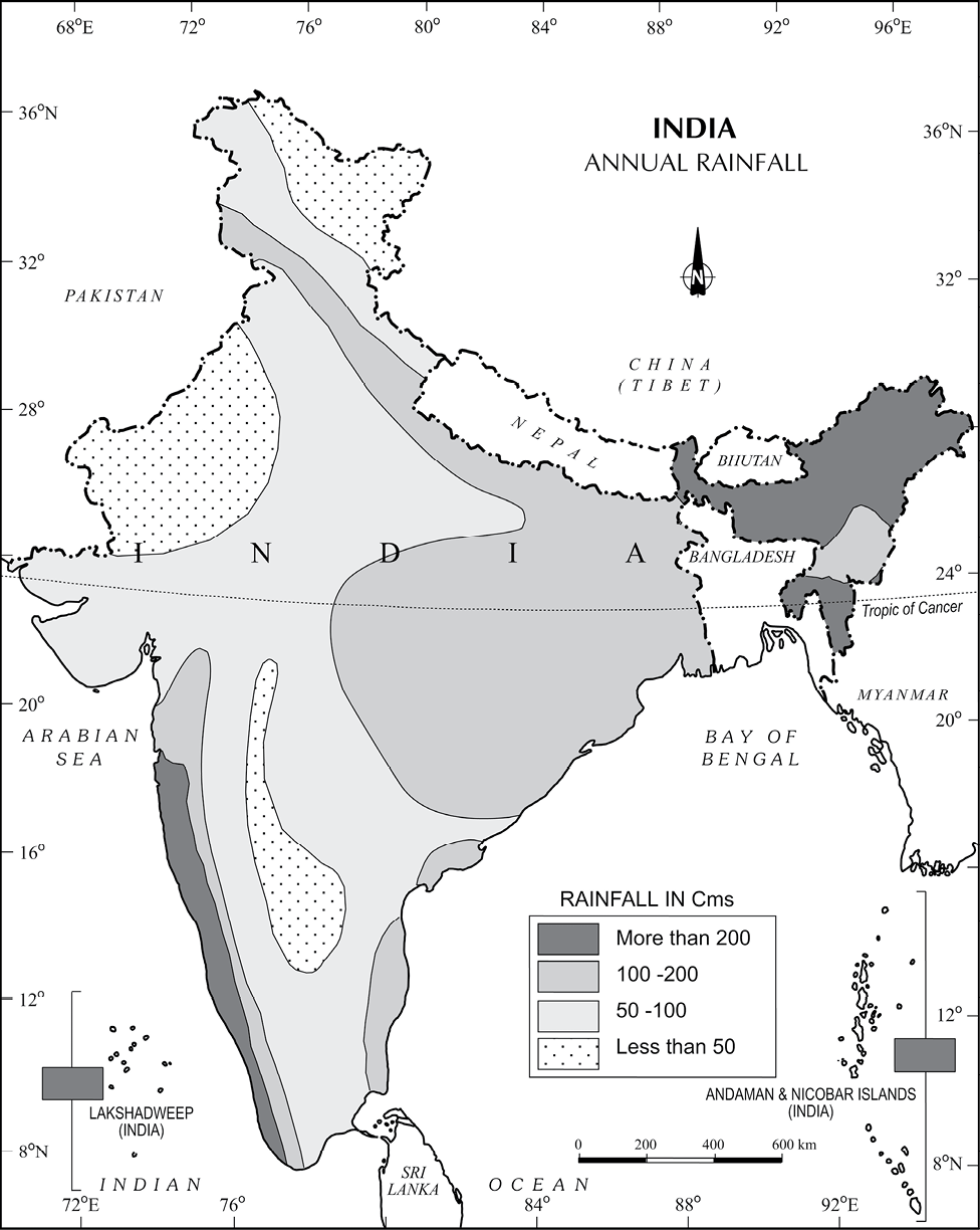
(ii) What is the proportion of area of India which receives annual rainfall less than 75 cm?
(a) Half (c) Two-third
(b) One-third (d) Three-fourth
(iii) Which one of the following is not a fact regarding South India?
(a) Diurnal range of temperature is less here.
(b) Annual range of temperature is less here.
(c) Temperatures here are high throughout the year.
(d) Extreme climatic conditions are found here.
(iv) Which one of the following phenomenon happens when the sun shines vertically over the Tropic of Capricorn in the southern hemisphere?
(a) High pressure develops over North-western India due to low temperatures.
(b) Low pressure develops over North-western India due to high temperatures.
(c) No changes in temperature and pressure occur in north-western India.
(d) ‘Loo’ blows in the North-western India.
2. Answer the following questions in about 30 words.
(i) What is the Inter-Tropical Convergene Zone?
(ii) What is meant by ‘bursting of monsoon’? Name the place of India which gets the highest rainfall.
(iii) Which type(s) of cyclones cause rainfall in north-western India during winter? Where do they originate?
3. Answer the following questions in not more than 125 words.
(i) Notwithstanding the broad climatic unity, the climate of India has many regional variations. Elaborate this statement giving suitable examples.
(ii) How many distinct seasons are found in India as per the Indian Meteorological Department? Discuss the weather conditions associated with any one season in detail.
Project/Activity
On the outline map of India, show the following:
(i) Areas of winter rain
(ii) Wind direction during the summer season
(iii) Areas having less than 15°°C temperature in January
(iv) Isohyte of 100 cm.