Table of Contents
Have you ever thought about the most important factor which supports trees, grasses, crops and numerous life-forms over the earth’s surface? Can one grow a blade of grass without soil? While some plants and organisms which are aquatic in nature can sustain in water, do they not derive nutrients from soil through water? You will realise that soil is the most important layer of the earth’s crust. It is a valuable resource. The bulk of our food and much of our clothing is derived from land-based crops that grow in the soil. The soil on which we depend so much for our day-to-day needs has evolved over thousands of years. The various agents of weathering and gradation have acted upon the parent rock material to produce a thin layer of soil.
Soil is the mixture of rock debris and organic materials which develop on the earth’s surface. The major factors affecting the formation of soil are relief, parent material, climate, vegetation and other life-forms and time. Besides these, human activities also influence it to a large extent. Components of the soil are mineral particles, humus, water and air. The actual amount of each of these depend upon the type of soil. Some soils are deficient in one or more of these, while there are some others that have varied combinations.
Have you ever dug a pit in the field of your school to plant a tree while celebrating Van-Mahotsava? Was the pit of uniform layer of soil or did you notice different colours from the top to the bottom of the pit?
If we dig a pit on land and look at the soil, we find that it consists of three layers which are called horizons. ‘Horizon A’ is the topmost zone, where organic materials have got incorporated with the mineral matter, nutrients and water, which are necessary for the growth of plants. ‘Horizon B’ is a transition zone between the ‘horizon A’ and ‘horizon C’, and contains matter derived from below as well as from above. It has some organic matter in it, although the mineral matter is noticeably weathered. ‘Horizon C’ is composed of the loose parent material. This layer is the first stage in the soil formation process and eventually forms the above two layers. This arrangement of layers is known as the soil profile. Underneath these three horizons is the rock which is also known as the parent rock or the bedrock. Soil, which is a complex and varied entity has always drawn the attention of the scientists. In order to understand its importance, it is essential to attempt a scientific study of the soil. Classification of the soil is an effort to achieve this objective.
Classification of Soils
India has varied relief features, landforms, climatic realms and vegetation types. These have contributed in the development of various types of soils in India.
In ancient times, soils used to be classified into two main groups – Urvara and Usara, which were fertile and sterile, respectively. In the 16th centrury A.D., soils were classified on the basis of their inherent characteristics and external features such as texture, colour, slope of land and moisture content in the soil. Based on texture, main soil types were identified as sandy, clayey, silty and loam, etc. On the basis of colour, they were red, yellow, black, etc.
Since Independence, scientific surveys of soils have been conducted by various agencies. Soil Survey of India, established in 1956, made comprehensive studies of soils in selected areas like in the Damodar Valley. The National Bureau of Soil Survey and the Land Use Planning an Institute under the control of the Indian Council of Agricultural Research (ICAR) did a lot of studies on Indian soils. In their effort to study soil and to make it comparable at the international level, the ICAR has classified the Indian soils on the basis of their nature and character as per the United States Department of Agriculture (USDA) Soil Taxonomy.
ICAR has classified the soils of India into the following order as per the USDA soil taxonomy
| Sl. No. | Order | Area(in Thousand Hectares) | Percentage |
| (i) | Inceptisols | 130372.90 | 39.74 |
| (ii) | Entisols | 92131.71 | 28.08 |
| (iii) | Alfisols | 44448.68 | 13.55 |
| (iv) | Vertisols | 27960.00 | 8.52 |
| (v) | Aridisols | 14069.00 | 4.28 |
| (vi) | Ultisols | 8250.00 | 2.51 |
| (vii) | Mollisols | 1320.00 | 0.40 |
| (viii) | Others | 9503.10 | 2.92 |
| Total | 100 | ||
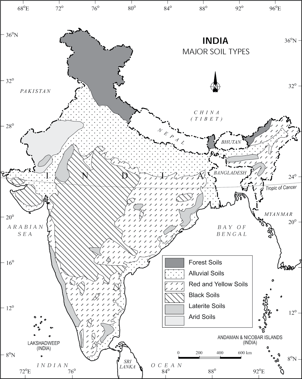
On the basis of genesis, colour, composition and location, the soils of India have been classified into:
(i) Alluvial soils
(ii) Black soils
(iii) Red and Yellow soils
(iv) Laterite soils
(v) Arid soils
(vi) Saline soils
(vii) Peaty soils
(viii) Forest soils.
Alluvial Soils
Alluvial soils are widespread in the northern plains and the river valleys. These soils cover about 40 per cent of the total area of the country. They are depositional soils, transported and deposited by rivers and streams. Through a narrow corridor in Rajasthan, they extend into the plains of Gujarat. In the Peninsular region, they are found in deltas of the east coast and in the river valleys.
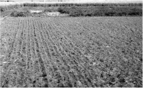
Figure 6.1 : Alluvial Soil
The alluvial soils vary in nature from sandy loam to clay. They are generally rich in potash but poor in phosphorous. In the Upper and Middle Ganga plain, two different types of alluvial soils have developed, viz. Khadar and Bhangar. Khadar is the new alluvium and is deposited by floods annually, which enriches the soil by depositing fine silts. Bhangar represents a system of older alluvium, deposited away from the flood plains. Both the Khadar and Bhangar soils contain calcareous concretions (Kankars). These soils are more loamy and clayey in the lower and middle Ganga plain and the Brahamaputra valley. The sand content decreases from the west to east.
The colour of the alluvial soils varies from the light grey to ash grey. Its shades depend on the depth of the deposition, the texture of the materials, and the time taken for attaining maturity. Alluvial soils are intensively cultivated.
Black Soil
Black soil covers most of the Deccan Plateau which includes parts of Maharashtra, Madhya Pradesh, Gujarat, Andhra Pradesh and some parts of Tamil Nadu. In the upper reaches of the Godavari and the Krishna, and the north western part of the Deccan Plateau, the black soil is very deep.
These soils are also known as the ‘Regur Soil’ or the ‘Black Cotton Soil’. The black soils are generally clayey, deep and impermeable. They swell and become sticky when wet and shrink when dried. So, during the dry season, these soil develop wide cracks. Thus, there occurs a kind of ‘self ploughing’. Because of this character of slow absorption and loss of moisture, the black soil retains the moisture for a very long time, which helps the crops, especially, the rain fed ones, to sustain even during the dry season.
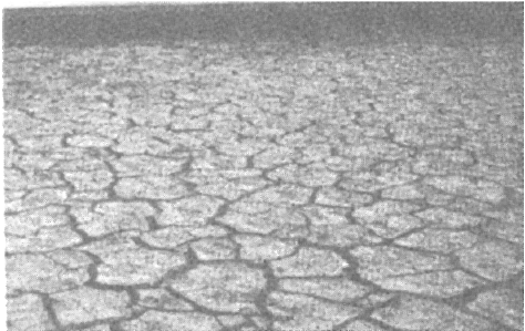
Figure 6.3 : Black Soil During Dry Season
Chemically, the black soils are rich in lime, iron, magnesia and alumina. They also contain potash. But they lack in phosphorous, nitrogen and organic matter. The colour of the soil ranges from deep black to grey.
Red and Yellow Soil
Red soil develops on crystalline igneous rocks in areas of low rainfall in the eastern and southern part of the Deccan Plateau. Along the piedmont zone of the Western Ghat, long stretch of area is occupied by red loamy soil. Yellow and red soils are also found in parts of Odisha and Chhattisgarh and in the southern parts of the middle Ganga plain. The soil develops a reddish colour due to a wide diffusion of iron in crystalline and metamorphic rocks. It looks yellow when it occurs in a hydrated form. The fine-grained red and yellow soils are normally fertile, whereas coarse-grained soils found in dry upland areas are poor in fertility. They are generally poor in nitrogen, phosphorous and humus.
Laterite Soil
Laterite has been derived from the Latin word ‘Later’ which means brick. The laterite soils develop in areas with high temperature and high rainfall. These are the result of intense leaching due to tropical rains. With rain, lime and silica are leached away, and soils rich in iron oxide and aluminium compound are left behind. Humus content of the soil is removed fast by bacteria that thrives well in high temperature. These soils are poor in organic matter, nitrogen, phosphate and calcium, while iron oxide and potash are in excess. Hence, laterites are not suitable for cultivation; however, application of manures and fertilisers are required for making the soils fertile for cultivation.
Red laterite soils in Tamil Nadu, Andhra Pradesh and Kerala are more suitable for tree crops like cashewnut.
Laterite soils are widely cut as bricks for use in house construction. These soils have mainly developed in the higher areas of the Peninsular plateau. The laterite soils are commonly found in Karnataka, Kerala, Tamil Nadu, Madhya Pradesh and the hilly areas of Odisha and Assam.
Arid Soils
Arid soils range from red to brown in colour. They are generally sandy in structure and saline in nature. In some areas, the salt content is so high that common salt is obtained by evaporating the saline water. Due to the dry climate, high temperature and accelerated evaporation, they lack moisture and humus. Nitrogen is insufficient and the phosphate content is normal.
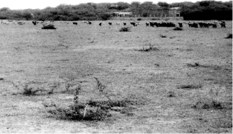
Figure 6.4 : Arid Soil
Lower horizons of the soil are occupied by ‘kankar’ layers because of the increasing calcium content downwards. The ‘Kankar’ layer formation in the bottom horizons restricts the infiltration of water, and as such when irrigation is made available, the soil moisture is readily available for a sustainable plant growth. Arid soils are characteristically developed in western Rajasthan, which exhibit characteristic arid topography. These soils are poor and contain little humus and organic matter.
Saline Soils
They are also known as Usara soils. Saline soils contain a larger proportion of sodium, potassium and magnesium, and thus, they are infertile, and do not support any vegetative growth. They have more salts, largely because of dry climate and poor drainage. They occur in arid and semi-arid regions, and in waterlogged and swampy areas. Their structure ranges from sandy to loamy. They lack in nitrogen and calcium. Saline soils are more widespread in western Gujarat, deltas of the eastern coast and in Sunderban areas of West Bengal. In the Rann of Kuchchh, the Southwest Monsoon brings salt particles and deposits there as a crust. Seawater intrusions in the deltas promote the occurrence of saline soils. In the areas of intensive cultivation with excessive use of irrigation, especially in areas of green revolution, the fertile alluvial soils are becoming saline. Excessive irrigation with dry climatic conditions promotes capillary action, which results in the deposition of salt on the top layer of the soil. In such areas, especially in Punjab and Haryana, farmers are advised to add gypsum to solve the problem of salinity in the soil.
Peaty Soils
They are found in the areas of heavy rainfall and high humidity, where there is a good growth of vegetation. Thus, large quantity of dead organic matter accumulates in these areas, and this gives a rich humus and organic content to the soil. Organic matter in these soils may go even up to 40-50 per cent. These soils are normally heavy and black in colour. At many places, they are alkaline also. It occurs widely in the northern part of Bihar, southern part of Uttarakhand and the coastal areas of West Bengal, Odisha and Tamil Nadu.
Forest Soils
As the name suggests, forest soils are formed in the forest areas where sufficient rainfall is available. The soils vary in structure and texture depending on the mountain environment where they are formed. They are loamy and silty on valley sides and coarse-grained in the upper slopes. In the snow-bound areas of the Himalayas, they experience denudation, and are acidic with low humus content. The soils found in the lower valleys are fertile.
It is evident from the foregoing discussions that soils, their texture, quality and nature are vital for the germination and growth of plant and vegetation including crops. Soils are living systems. Like any other organism, they too develop and decay, get degraded, respond to proper treatment if administered in time. These have serious repercussions on other components of the system of which they themselves are important parts.
Soil Degradation
In a broad sense, soil degradation can be defined as the decline in soil fertility, when the nutritional status declines and depth of the soil goes down due to erosion and misuse. Soil degradation is the main factor leading to the depleting soil resource base in India. The degree of soil degradation varies from place to place according to the topography, wind velocity and amount of the rainfall.
Soil Erosion
The destruction of the soil cover is described as soil erosion. The soil forming processes and the erosional processes of running water and wind go on simultaneously. But generally, there is a balance between these two processes. The rate of removal of fine particles from the surface is the same as the rate of addition of particles to the soil layer.
Sometimes, such a balance is disturbed by natural or human factors, leading to a greater rate of removal of soil. Human activities too are responsible for soil erosion to a great extent. As the human population increases, the demand on the land also increases. Forest and other natural vegetation is removed for human settlement, for cultivation, for grazing animals and for various other needs.
Wind and water are powerful agents of soil erosion because of their ability to remove soil and transport it. Wind erosion is significant in arid and semi-arid regions. In regions with heavy rainfall and steep slopes, erosion by running water is more significant. Water erosion which is more serious and occurs extensively in different parts of India, takes place mainly in the form of sheet and gully erosion. Sheet erosion takes place on level lands after a heavy shower and the soil removal is not easily noticeable. But it is harmful since it removes the finer and more fertile top soil. Gully erosion is common on steep slopes. Gullies deepen with rainfall, cut the agricultural lands into small fragments and make them unfit for cultivation. A region with a large number of deep gullies or ravines is called a badland topography. Ravines are widespread, in the Chambal basin. Besides this, they are also found in Tamil Nadu and West Bengal. The country is losing about 8,000 hectares of land to ravines every year. What types are prone to gully erosion?
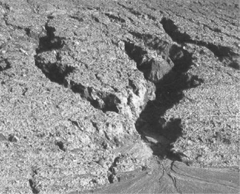
Soil erosion is a serious problem for Indian agriculture and its negative effects are seen in other spheres also. Eroded materials are carried down to rivers and they lower down their carrying capacity, and cause frequent floods and damage to agricultural lands.
Deforestation is one of the major causes of soil erosion. Plants keep soils bound in locks of roots, and thus, prevent erosion. They also add humus to the soil by shedding leaves and twigs. Forests have been denuded practically in most parts of India but their effect on soil erosion are more in hilly parts of the country.
A fairly large area of arable land in the irrigated zones of India is becoming saline because of over-irrigation. The salt lodged in the lower profiles of the soil comes up to the surface and destroys its fertility. Chemical fertilisers in the absence of organic manures are also harmful to the soil. Unless the soil gets enough humus, chemicals harden it and reduce its fertility in the long run. This problem is common in all the command areas of the river valley projects, which were the first beneficiaries of the Green Revolution. According to estimates, about half of the total land of India is under some degree of degradation.
Every year, India loses millions of tonnes of soil and its nutrients to the agents of its degradation, which adversely affects our national productivity. So, it is imperative to initiate immediate steps to reclaim and conserve soils.
Soil Conservation
If soil erosion and exhaustion are caused by humans; by corollary, they can also be prevented by humans. Nature has its own laws of maintaining balance. Nature offers enough opportunities for humans to develop their economy without disturbing the ecological balance. Soil conservation is a methodology to maintain soil fertility, prevent soil erosion and exhaustion, and improve the degraded condition of the soil.
Soil erosion is essentially aggravated by faulty practices. The first step in any rational solution is to check open cultivable lands on slopes from farming. Lands with a slope gradient of 15 - 25 per cent should not be used for cultivation. If at all the land is to be used for agriculture, terraces should carefully be made. Over-grazing and shifting cultivation in many parts of India have affected the natural cover of land and given rise to extensive erosion. It should be regulated and controlled by educating villagers about the consequences. Contour bunding, Contour terracing, regulated forestry, controlled grazing, cover cropping, mixed farming and crop rotation are some of the remedial measures which are often adopted to reduce soil erosion.
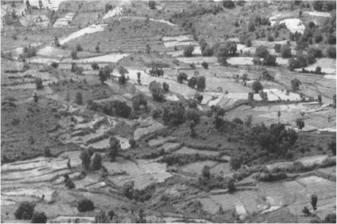
Figure 6.6 : Terrace Farming
Efforts should be made to prevent gully erosion and control their formation. Finger gullies can be eliminated by terracing. In bigger gullies, the erosive velocity of water may be reduced by constructing a series of check dams. Special attention should be made to control headward extension of gullies. This can be done by gully plugging, terracing or by planting cover vegetation.
In arid and semi-arid areas, efforts should be made to protect cultivable lands from encroachment by sand dunes through developing shelter belts of trees and agro-forestry. Lands not suitable for cultivation should be converted into pastures for grazing. Experiments have been made to stabilise sand dunes in western Rajasthan by the Central Arid Zone Research Institute (CAZRI).
The Central Soil Conservation Board, set up by the Government of India, has prepared a number of plans for soil conservation in different parts of the country. These plans are based on the climatic conditions, configuration of land and the social behaviour of people. Even these plans are fragmental in nature. Integrated land use planning, therefore, seems to be the best technique for proper soil conservation. Lands should be classified according to their capability; land use maps should be prepared and lands should be put to right uses. The final responsibility for achieving the conservation of land will rest on the people who operate on it and receive the benefits.
EXERCISES
1. Choose the right answer from the four alternatives given below.
(i) Which one of the following is the most widespread and most productive category of soil?
(a) Alluvial Soil
(c) Black Soil
(b) Laterite Soil
(d) Forest Soil
(ii) ‘Regur Soil’ is another name for the.
(a) Saline Soil
(c) Black Soil
(b) Arid Soil
(d) Laterite Soil
(iii) Which one of the following is the main reason for the loss of the top soil in India?
(a) Wind erosion
(c) Excessive leaching
(b) Water erosion
(d) None of these
(iv) Arable land in the irrigated zones of India is turning saline due to which of the following reasons?
(a) Addition of gypsum
(c) Over irrigation
(b) Over grazing
(d) Use of fertilisers
2. Answer the following questions in about 30 words.
(i) What is soil?
(ii) What are the main factors responsible for the formation of soil?
(iii) Mention the three horizons of a soil profile.
(iv) What is soil degradation?
(v) What is the difference between Khadar and Bhangar?
3. Answer the following questions in not more than 125 words.
(i) What are black soils? Describe their formation and characteristics.
(ii) What is soil conservation? Suggest some measures to conserve soil.
(iii) How do you know that a particular type of soil is fertile or not? Differentiate between naturally determined fertility and culturally induced fertility.
Project/Activity
1. Collect various samples of soil and prepare a report on the type(s) of soils found in your region.
2. On an outline map of India, mark the areas coverd by the following soil categories.
(i) Red soil
(ii) Laterite soil
(iii) Alluvial soil.
