Table of Contents

Unit-IV
Chapter-10
Human Settlements

We all live in clusters of houses. You may call it a village, a town or a city, all are examples of human settlements. The study of human settlements is basic to human geography because the form of settlement in any particular region reflects human relationship with the environment. A human settlement is defined as a place inhabited more or less permanently. The houses may be designed or redesigned, buildings may be altered, functions may change but settlement continues in time and space. There may be some settlements which are temporary and are occupied for short periods, may be a season.
Classification of settlements Rural Urban Dichotomy
It is widely accepted that settlements can be differentiated in terms of rural and urban, but there is no consensus on what exactly defines a village or a town. Although population size is an important criterion, it is not a universal criterion since many villages in densely populated countries of India and China have population exceeding that of some towns of Western Europe and United States.
At one time, people living in villages pursued agriculture or other primary activities, but presently in developed countries, large sections of urban populations prefer to live in villages even though they work in the city. The basic difference between towns and villages is that in towns the main occupation of the people is related to secondary and tertiary sectors, while in the villages most of the people are engaged in primary occupations such as agriculture, fishing, lumbering, mining, animal husbandry, etc.
Sub Urbanisation
It is a new trend of people moving away from congested urban areas to cleaner areas outside the city in search of a better quality of living. Important suburbs develop around major cities and everyday thousands of people commute from their homes in the sub urbs to their work places in the city.
Differentiations between rural and urban on the basis of functions are more meaningful even though there is no uniformity in the hierarchy of the functions provided by rural and urban settlements. Petrol pumps are considered as a lower order function in the United States while it is an urban function in India. Even within a country, rating of functions may vary according to the regional economy. Facilities available in the villages of developed countries may be considered rare in villages of developing and less developed countries.
The census of India, 1991 defines urban settlements as “All places which have municipality, corporation, cantonment board or notified town area committee and have a minimum population of 5000 persons, at least 75 per cent of male workers are engaged in non-agricultural pursuits and a density of population of at least 400 persons per square kilometers are urban.
Types and Patterns of Settlements
Settlements may also be classified by their shape, patterns types. The major types classified by shape are:
(i) Compact or Nucleated settlements: These settlements are those in which large number of houses are built very close to each other. Such settlements develop along river valleys and in fertile plains. Communities are closely knit and share common occupations.
(ii) Dispersed Settlements: In these settlements, houses are spaced far apart and often interspersed with fields. A cultural feature such as a place of worship or a market, binds the settlement together.
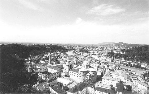
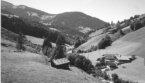
Fig. 10.2: Dispersed Settlements
Rural Settlements
Rural settlements are most closely and directly related to land. They are dominated by primary activities such as agriculture, animal husbandary, fishing etc. The settlements size is relatively small. Some factors affecting the location of rural settlements are :
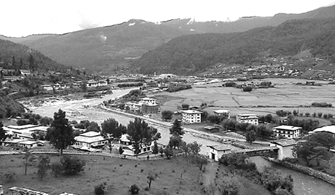
Fig. 10.3 : Siting near water
Water Supply
Usually rural settlements are located near water bodies such as rivers, lakes, and springs where water can be easily obtained. Sometimes the need for water drives people to settle in otherwise disadvantaged sites such as islands surrounded by swamps or low lying river banks. Most water based ‘wet point’ settlements have many advantages such as water for drinking, cooking and washing. Rivers and lakes can be used to irrigate farm land. Water bodies also have fish which can be caught for diet and navigable rivers and lakes can be used for transportation.
Land
People choose to settle near fertile lands suitable for agriculture. In Europe villages grew up near rolling country avoiding swampy, low lying land while people in south east Asia chose to live near low lying river valleys and coastal plains suited for wet rice cultivation. Early settlers chose plain areas with fertile soils.
Upland
Upland which is not prone to flooding was chosen to prevent damage to houses and loss of life. Thus, in low lying river basins people chose to settle on terraces and levees which are “dry points”. In tropical countries people build their houses on stilts near marshy lands to protect themselves from flood, insects and animal pests.
Building Material
The availability of building materials- wood, stone near settlements is another advantage. Early villages were built in forest clearings where wood was plentiful.
In loess areas of China, cave dwellings were important and African Savanna’s building materials were mud bricks and the Eskimos, in polar regions, use ice blocks to construct igloos.
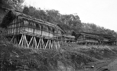
Fig. 10.4 : House on stilts
Defence
During the times of political instability, war, hostility of neighbouring groups villages were built on defensive hills and islands. In Nigeria, upstanding inselbergs formed good defensive sites. In India most of the forts are located on higher grounds or hills.
Planned Settlements
Sites that are not spontaneously chosen by villagers themselves, planned settlements are constructed by governments by providing shelter, water and other infrastructures on acquired lands. The scheme of villagisation in Ethiopia and the canal colonies in Indira Gandhi canal command area in India are some good examples.
Rural Settlement Patterns
Patterns of rural settlements reflect the way the houses are sited in relation to each other. The site of the village, the surrounding topography and terrain influence the shape and size of a village.
Rural settlements may be classified on the basis of a number of criteria:
(i) On the basis of setting: The main types are plain villages, plateau villages, coastal villages, forest villages and desert villages.
(ii) On the basis of functions: There may be farming villages, fishermen’s villages, lumberjack villages, pastoral villages etc.
(iii) On the basis of forms or shapes of the settlements: These may be a number of geometrical forms and shapes such as Linear, rectangular, circular star like, T-shaped village, double village, cross-shaped village etc.
(a) Linear pattern: In such settlements houses are located along a road, railway line, river, canal edge of a valley or along a levee.
(b) Rectangular pattern: Such patterns of rural settlements are found in plain areas or wide inter montane valleys. The roads are rectangular and cut each other at right angles.
(c) Circular pattern: Circular villages develop around lakes, tanks and sometimes the village is planned in such a way that the central part remains open and is used for keeping the animals to protect them from wild animals.
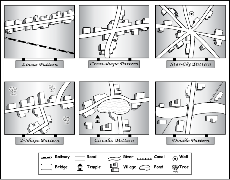
Fig 10.5: Rural settlement Patterns
(d) Star like pattern: Where several roads converge, star shaped settlements develop by the houses built along the roads.
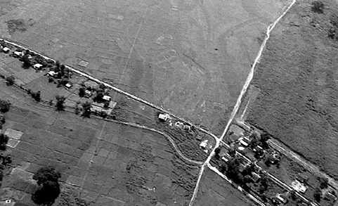
Fig.10.6 : Linear pattern settlement
(e) T-shaped, Y-shaped, Cross-shaped or cruciform settlements: T-shaped settlements develop at tri-junctions of the roads ( ) while
  -shaped settlements emerge as the places where two roads converge on the third one and houses are built along these roads. Cruciform settlements develop on the cross-roads and houses extend in all the four direction.
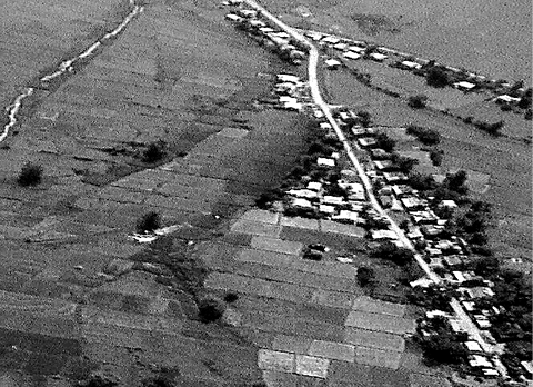
Fig.10.7 : Y shape settlement
(f) Double village: These settlements extend on both sides of a river where there is a bridge or a ferry.

Identify these patterns on any topographical sheet which you have studied in Practical Work in Geography, Part I (NCERT, 2006) in Class XI
Problems of Rural Settlements
Rural settlements in the developing countries are large in number and poorly equipped with infrastructure. They represent a great challenge and opportunity for planners.
Supply of water to rural settlements in developing countries is not adequate. People in villages, particularly in mountainous and arid areas have to walk long distances to fetch drinking water. Water borne diseases such as cholera and jaundice tend to be a common problem. The countries of South Asia face conditions of drought and flood very often. Crop cultivation sequences, in the absence of irrigation, also suffer.
The general absence of toilet and garbage disposal facilities cause health related problems.
The design and use of building materials of houses vary from one ecological region to another. The houses made up of mud, wood and thatch, remain susceptible to damage during heavy rains and floods, and require proper maintenance every year. Most house designs are typically deficient in proper ventilation. Besides, the design of a house includes the animal shed along with its fodder-store within it. This is purposely done to keep the domestic animals and their food properly protected from wild animals.
Unmetalled roads and lack of modern communication network creates a unique problem. During rainy season, the settlements remain cut off and pose serious difficulties in providing emergency services. It is also difficult to provide adequate health and educational infrastructure for their large rural population. The problem is particularly serious where proper villagisation has not taken place and houses are scattered over a large area.
Urban Settlements
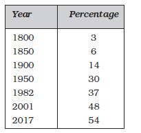
Rapid urban growth is a recent phenomenon. Until recent times, few settlements reached the population size of more than a few thousand inhabitants. The first urban settlement to reach a population of one million was the city of London by around. A.D. 1810 By 1982 approximately 175 cities in the world had crossed the one million population mark. Presently 54 per cent of the world’s population lives in urban settlements compared to only 3 per cent in the year 1800 (Table 10.1).
Table 10.1: Percentage of World’s Population Living in Urban Areas
Classification of Urban Settlements
The definition of urban areas varies from one country to another. Some of the common basis of classification are size of population, occupational structure and administrative setup.
Population Size
It is an important criteria used by most countries to define urban areas. The lower limit of the population size for a settlement to be designated as urban is 1,500 in Colombia, 2,000 in Argentina and Portugal, 2,500 in U.S.A. and Thailand, 5,000 in India and 30,000 in Japan. Besides the size of population, density of 400 persons per sq km and share of non-agricultural workers are taken into consideration in India. Countries with low density of population may choose a lower number as the cut-off figure compared to densely populated countries. In Denmark, Sweden and Finland, all places with a population size of 250 persons are called urban. The minimum population for a city is 300 in Iceland, whereas in Canada and Venezuela, it is 1,000 persons.
Occupational Structure
In some countries, such as India, the major economic activities in addition to the size of the population in designating a settlement as urban are also taken as a criterion. Similarly, in Italy, a settlement is called urban, if more than 50 per cent of its economically productive population is engaged in non-agricultural pursuits. India has set this criterion at 75 per cent.
Administration
The administrative setup is a criterion for classifying a settlement as urban in some countries. For example, in India, a settlement of any size is classified as urban, if it has a municipality, Cantonment Board or Notified Area Council. Similarly, in Latin American countries, such as Brazil and Bolivia, any administrative centre is considered urban irrespective of its population size.
Location
Location of urban centres is examined with reference to their function. For example, the sitting requirements of a holiday resort are quite different from that of an industrial town, a military centre or a seaport. Strategic towns require sites offering natural defence; mining towns require the presence of economically valuable minerals; industrial towns generally need local energy supplies or raw materials; tourist centres require attractive scenery, or a marine beach, a spring with medicinal water or historical relics, ports require a harbour etc.
Locations of the earliest urban settlements were based on the availability of water, building materials and fertile land. Today, while these considerations still remain valid, modern technology plays a significant role in locating urban settlements far away from the source of these materials. Piped water can be supplied to a distant settlement, building material can be transported from long distances.
Apart from site, the situation plays an important role in the expansion of towns. The urban centres which are located close to an important trade route have experienced rapid development.
Functions of Urban Centres
The earliest towns were centres of administration, trade, industry, defence and religious importance. The significance of defence and religion as differentiating functions has declined in general, but other functions have entered the list. Today, several new functions, such as, recreational, residential, transport, mining, manufacturing and most recently activities related to information technology are carried on in specialised towns. Some of these functions do not necessarily require the urban centre to have any fundamental relationship with their neighbouring rural areas.
What would be the effects of Information and Communication Technology (ICT) as a function on the development of existing and new settlements?
Prepare a list of cities where earlier functions have been replaced by newer ones.
In spite of towns performing multiple functions we refer to their dominant function. For example, we think of Sheffield as an industrial city, London as a port city, Chandigarh as an administrative city and so on. Large cities have a rather greater diversity of functions. Besides, all cities are dynamic and over a period of time may develop new functions. Most of the early nineteenth-century fishing ports in England have now developed tourism. Many of the old market towns are now known for manufacturing activities. Towns and cities are classified into the following categories.
Administrative Towns
National capitals, which house the administrative offices of central governments, such as New Delhi, Canberra, Beijing, Addis Ababa, Washington D.C., and London etc. are called administrative towns. Provincial (sub-national) towns can also have administrative functions, for example, Victoria (British Columbia), Albany (New York), Chennai (Tamil Nadu).
Trading and Commercial Towns
Agricultural market towns, such as, Winnipeg and Kansas city; banking and financial centres like Frankfurt and Amsterdam; large inland centres like Manchester and St Louis; and transport nodes such as, Lahore, Baghdad and Agra have been important trading centres.
Cultural Towns
Places of pilgrimage, such as Jerusalem, Mecca, Jagannath Puri and Varanasi etc. are considered cultural towns. These urban centres are of great religious importance.
Additional functions which the cities perform are health and recreation (Miami and Panaji), industrial (Pittsburgh and Jamshedpur), mining and quarrying (Broken Hill and Dhanbad) and transport (Singapore and Mughal Sarai).

Urbanisation means the increase in the proportion population of a country who live in urban areas.
The most important cause of urbanisation is rural-urban migration. During the late 1990s some 20 to 30 million people were leaving the countryside every year and moving into towns and cities.
Developed countries experienced rapid urbanisation during the nineteenth century.
Developing counties experienced rapid urbanisation during the second half of the twentieth century.
Classification of Towns on the basis of Forms
An urban settlement may be linear, square, star or crescent shaped. In fact, the form of the settlement, architecture and style of buildings and other structures are an outcome of its historical and cultural traditions.
Towns and cities of developed and developing countries reflect marked differences in planning and development. While most cities in developed countries are planned, most urban settlements of developing countries have evolved historically with irregular shapes. For example, Chandigarh and Canberra are planned cities, while smaller town in India have evolved historically from walled cities to large urban sprawls.
Addis Ababa (The New Flower)
The name of Ethiopian capital Addis Ababa, as the name indicates (Addis-New, Ababa-Flower) is a ‘new’ city which was established in 1878.
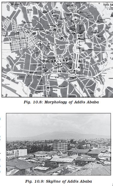
The whole city is located on a hill-valley topography. The road pattern bears the influence of the local topography. The roads radiate from the govt headquarters Piazza, Arat and Amist Kilo roundabouts. Mercato has markets which grew with time and is supposed to be the largest market between Cairo and Johannesburg. A multi-faculty university, a medical college, a number of good schools make Addis Ababa an educational centre. It is also the terminal station for the Djibouti-Addis Ababa rail route. Bole airport is a relatively new airport. The city has witnessed rapid growth because of its multi-functional nature and being a large nodal centre located in the centre of Ethiopia.
Canberra
Canberra was planned as the capital of Australia in 1912 by American landscape architect, Walter Burley Griffin. He had envisaged a garden city for about 25,000 people taking into account the natural features of the landscape. There were to be five main centres, each with separate city functions. During the last few decades, the city has expanded to accommodate several satellite towns, which have their own centres. The city has wide-open spaces and many parks and gardens.
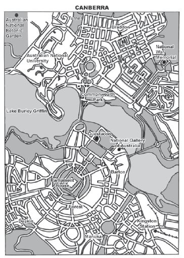
Fig. 10.10 : Morphology of a planned city – Canberra
Types of Urban Settlements
Depending on the size and the services available and functions rendered, urban centres are designated as town, city, million city, conurbation, megalopolis.
Town
The concept of ‘town’ can best be understood with reference to ‘village’. Population size is not the only criterion. Functional contrasts between towns and villages may not always be clear-cut, but specific functions such as, manufacturing, retail and wholesale trade, and professional services exist in towns.
City
A city may be regarded as a leading town, which has outstripped its local or regional rivals. In the words of Lewis Mumford, “ the city is in fact the physical form of the highest and most complex type of associative life”. Cities are much larger than towns and have a greater number of economic functions. They tend to have transport terminals, major financial institutions and regional administrative offices. When the population crosses the one million mark it is designated as a million city.
Conurbation
The term conurbation was coined by Patrick Geddes in 1915 and applied to a large area of urban development that resulted from the merging of originally separate towns or cities. Greater London, Manchester, Chicago and Tokyo are examples. Can you find out an example from India?
Million City
The number of million cities in the world has been increasing as never before. London reached the million mark in 1800, followed by Paris in 1850, New York in 1860, and by 1950 there were around 80 such cities. There were 162 million cities in mid 70’s and there was threefold increase in 2005 and the number reached to 438. In 2016, there were 512 cities with at least 1 million inhabitants globally. By 2030, a projected 662 cities will have at least 1 million residents.
Megalopolis
This Greek word meaning “great city”, was popularised by Jean Gottman (1957) and signifies ‘super- metropolitan’ region extending, as union of conurbations. The urban landscape stretching from Boston in the north to south of Washington in U.S.A. is the best known example of a megalopolis.
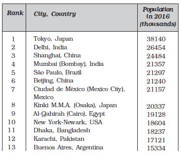
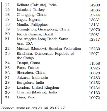
Distribution of Mega Cities
A mega city or megalopolis is a general term for cities together with their suburbs with a population of more than 10 million people. New York was the first to attain the status of a mega city by 1950 with a total population of about 12.5 million. The number of mega cities is now 31. The number of mega cities has increased in the developing countries during the last 50 years vis-à-vis the developed countries.
Table 10.2: Mega Cities of the World
Problems of Human Settlements in Developing Countries
The settlements in developing countries, suffer from various problems, such as unsustainable concentration of population, congested housing and streets, lack of drinking water facilities. They also lack infrastructure such as, electricity, sewage disposal, health and education facilities.
Rural/Urban Problems
Can you identify the problems faced by your city/town/village in terms of any one of the following?
Availability of potable water.
Electricity supply.
Sewerage system.
Transportation and communication facilities.
Health and educational infrastructure.
Water and air pollution.
Can you think of solutions to these problems?
Problems of Urban Settlements
People flock to cities to avail of employment opportunities and civic amenities. Since most cities in developing countries are unplanned, it creates severe congestion. Shortage of housing, vertical expansion and growth of slums are characteristic features of modern cities of developing countries. In many cities an increasing proportion of the population lives in substandard housing, e.g. slums and squatter settlements. In most million plus cities in India, one in four inhabitants lives in illegal settlements, which are growing twice as fast as the rest of the cities. Even in the Asia Pacific countries, around 60 per cent of the urban population lives in squatter settlements.
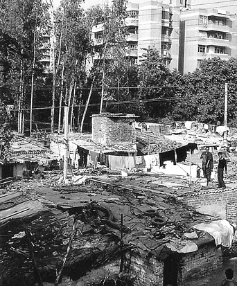
Fig. 10.11: Slums
What is a Healthy City?
World Health Organisation (WHO) suggests that, among other things, a ‘healthy city’ must have:
A ’Clean’ and ‘Safe’ environment.
Meets the ‘Basic Needs’ of ‘All’ its inhabitants.
Involves the ‘Community’ in local government.
Provides easily accessible ‘Health’ service.
Economic Problems
The decreasing employment opportunities in the rural as well as smaller urban areas of the developing countries consistently push the population to the urban areas. The enormous migrant population generates a pool of un-skilled and semi-skilled labour force, which is already saturated in urban areas.
Socio-cultural Problems
Cities in the developing countries suffer from several social ills. Insufficient financial resources fail to create adequate social infrastructure catering to the basic needs of the huge population. The available educational and health facilities remain beyond the reach of the urban poor. Health indices also, present a gloomy picture in cities of developing countries. Lack of employment and education tends to aggravate the crime rates. Male selective migration to the urban areas distorts the sex ratio in these cities.
Environmental Problems
The large urban population in developing countries not only uses but also disposes off a huge quantity of water and all types of waste materials. Many cities of the developing countries even find it extremely difficult to provide the minimum required quantity of potable water and water for domestic and industrial uses. An improper sewerage system creates unhealthy conditions. Massive use of traditional fuel in the domestic as well as the industrial sector severely pollutes the air. The domestic and industrial wastes are either let into the general sewerages or dumped without treatment at unspecified locations. Huge concrete structures erected to accommodate the population and economic play a very conducive role to create heat islands.
Urban Strategy
The United Nations Development Programme (UNDP) has outlined these priorities as part of its ‘Urban Strategy’.
Increasing ‘Shelter’ for the urban poor.
Provision of basic urban services such as ‘Education’, ‘Primary Health care’, ‘Clean Water and Sanitation’.
Improving women’s access to ‘Basic Services’ and government facilities.
Upgrading ‘Energy’ use and alternative ‘Transport’ systems.
Reducing ‘Air Pollution’.
Cities, towns and rural settlements are linked through the movements of goods, resources and people. Urban-rural linkages are of crucial importance for the sustainability of human settlements. As the growth of rural population has outpaced the generation of employment and economic opportunities, rural-to-urban migration has steadily increased, particularly in the developing countries, which has put an enormous pressure on urban infrastructure and services that are already under serious stress. It is urgent to eradicate rural poverty and to improve the quality of living conditions, as well as to create employment and educational opportunities in rural settlements. Full advantage must be taken of the complementary contributions and linkages of rural and urban areas by balancing their different economic, social and environmental requirements.
Exercises
1. Choose the right answer from the four alternatives given below.
(i) Which one of the following forms of settlement develops along either side of roads, rivers or canals?
(a) circular (c) cross-shaped
(b) linear (d) square
(ii) Which one of the following types of economic activities dominates in all rural settlement?
(a) primary (c) secondary
(b) tertiary (d) quaternary
(iii) In which of the following regions has the oldest well-documented urban settlement found?
(a) Huang He Valley (c) Nile Valley
(b) Indus Valley (d) Mesopotamia
(iv) How many of the following cities in India have attained the million status at the beginning of 2006?
(a) 40 (c) 41
(b) 42 (d) 43
(v) Sufficiency of which type of resources can help to create adequate social infrastructure catering to the needs of the large population in the developing countries?
(a) financial (c) natural
(b) human (d) social
2. Answer the following questions in about 30 words.
(i) How would you define a settlement?
(ii) Distinguish between site and situation.
(iii) What are the bases of classifying settlements?
(iv) How would you justify the study of human settlements in human geography?
3. Answer the following questions in not more than 150 words.
(i) What are rural and urban settlements? Mention their characteristics.
(ii) Discuss the problems associated with urban settlements in developing countries.
Project/Activity
(i) Do you live in a city? If not, do you live nearby? Is your life somehow linked to a city?
(a) What is its name?
(b) When was it first settled?
(c) Why was the site chosen?
(d) What is its population?
(e) What are the functions it performs?
(f) On a sketch of the city, try to identify the areas where these functions are performed.
Each student should make a list of five things associated with the selected city; things that cannot be found elsewhere. This is a mini definition of the city as each student sees it. The lists should be shared with the class. How much agreement is there between the lists?
(ii) Can you think of some ways by which you can single handedly help reduce pollution levels of your settlement
Hints :
(a) Proper garbage disposal
(b) Using public transport
(c) Better management of domestic water consumption
(d) Planting trees in the neighbourhood